Pakkhat geodata
Pakkhat (Nong Khai) is a seat of a second-order administrative division; located in Thailand in Asia/Bangkok (GMT+7) time zone. In our database, there are 331 cities with bigger population. Compared to other cities in Thailand, 91.3% of cities are located further ↓South; 83.3% of cities are located further ←West and 71.4% of cities have lower elevation than Pakkhat. Note1


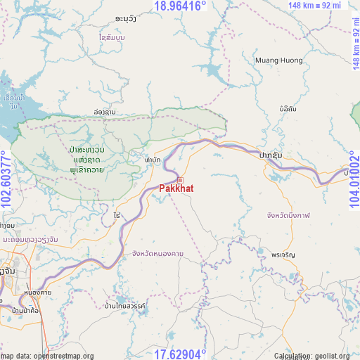
Pakkhat GPS coordinates[2]
18° 17' 52.404" North, 103° 18' 24.804" East
| Map corner | latitude | longitude |
|---|---|---|
| Upper-left | 18.96416°, | 102.60377° |
| Center: | 18.29789°, | 103.30689° |
| Lower-right: | 17.62904°, | 104.01002° |
| Map W x H: | 148.5×148.5 km | = 92.3×92.3mi |
| max Lat: | 20.43353° ⇑8.7% North |
| Pakkhat: | 18.29789° |
| min Lat: | ⇓91.3% South 5.77434° |
| min Long | Pakkhat | max Long |
| 97.93288° | 103.30689° | 105.49506° |
| W 83.3%⇐ | ⇒16.7% E |
Elevation
Elevation of Pakkhat is 173 m = 568 ft, and this is 47.5 m = 156 ft above average elevation for this country.
| Max E: |
1011 m = 3317 ft | 28.6% |
| Pakkhat | 173 m 568 ft | |
| Avg. | 125.5 m = 412 ft | |
Min E: |
1 m = 3 ft | 71.4% |
See also: Thailand elevation on elevation.city.
Geographical zone
Pakkhat is located in North Torrid zone (between Equator and Tropic of Cancer). Distance of this Northern Tropic circle is 571.4 km =355.1 mi to North.| Distance of | km | miles | from Pakkhat |
|---|---|---|---|
| North Pole | 7972.5 | 4953.9 | to North |
| Arctic Circle | 5366.6 | 3334.6 | to North |
| Tropic Cancer | 571.4 | 355.1 | to North |
| Equator | 2034.5 | 1264.2 | to South |


Nearby cities:
15 places around Pakkhat: (largest is in red/bold)
• Ban Dung
66.8 km =41.5 mi,  184°
184°
• Ban Muang
56.9 km =35.4 mi,  150°
150°
• Bueng Kan
37.1 km =23.1 mi,  78°
78°
• Bung Khla
70.4 km =43.7 mi,  89°
89°
• Fao Rai
31.1 km =19.3 mi, 180°
• Kham Ta Kla
68.7 km =42.7 mi,  136°
136°
• Pak Khat
0.9 km =0.6 mi,  342°
342°
• Phon Charoen
32.9 km =20.4 mi,  206°
206°
• Phon Charoen
51.9 km =32.2 mi,  124°
124°
• Phon Phisai
39.2 km =24.4 mi,  218°
218°
• Phonphisai
39.2 km =24.4 mi, 218°
• Rattanawapi
16.4 km =10.2 mi,  235°
235°
• Sang Khom
57.1 km =35.5 mi,  203°
203°
• Si Wilai
48.3 km =30 mi,  105°
105°
• So Phisai
28.5 km =17.7 mi, 149°
Sources, notices
• [Note1] Compared only with cities in Thailand existing in our database
• [Src1] Map data: © OpenStreetMap contributors (CC-BY-SA)
• [Src2] Other city data from geonames.org with taken over terms of usage.
• [Src3] Geographical zone / Annual Mean Temperature by Robert A. Rohde @ Wikipedia
