Bueng Kan geodata
Bueng Kan (Changwat Bueng Kan) is a seat of a first-order administrative division; located in Thailand in Asia/Bangkok (GMT+7) time zone. With population of 9,712 people, there are 286 cities with bigger population in this country. Compared to other cities in Thailand, 92% of cities are located further ↓South; 86.3% of cities are located further ←West and 65.2% of cities have lower elevation than Bueng Kan. Note1


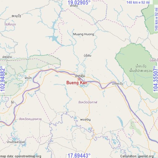
Bueng Kan GPS coordinates[2]
18° 21' 46.908" North, 103° 39' 6.984" East
| Map corner | latitude | longitude |
|---|---|---|
| Upper-left | 19.02905°, | 102.94882° |
| Center: | 18.36303°, | 103.65194° |
| Lower-right: | 17.69443°, | 104.35507° |
| Map W x H: | 148.4×148.4 km | = 92.2×92.2mi |
| max Lat: | 20.43353° ⇑8% North |
| Bueng Kan: | 18.36303° |
| min Lat: | ⇓92% South 5.77434° |
| min Long | Bueng Kan | max Long |
| 97.93288° | 103.65194° | 105.49506° |
| W 86.3%⇐ | ⇒13.7% E |
Elevation
Elevation of Bueng Kan is 160 m = 525 ft, and this is 34.5 m = 113 ft above average elevation for this country.
| Max E: |
1011 m = 3317 ft | 34.8% |
| Bueng Kan | 160 m 525 ft | |
| Avg. | 125.5 m = 412 ft | |
Min E: |
1 m = 3 ft | 65.2% |
See also: Thailand elevation on elevation.city.
Geographical zone
Bueng Kan is located in North Torrid zone (between Equator and Tropic of Cancer). Distance of this Northern Tropic circle is 564.1 km =350.5 mi to North.| Distance of | km | miles | from Bueng Kan |
|---|---|---|---|
| North Pole | 7965.3 | 4949.4 | to North |
| Arctic Circle | 5359.4 | 3330.2 | to North |
| Tropic Cancer | 564.1 | 350.5 | to North |
| Equator | 2041.8 | 1268.7 | to South |


Nearby cities:
15 places around Bueng Kan: (largest is in red/bold)
• Ban Muang
57.6 km =35.8 mi,  188°
188°
• Bueng Khong Long
61.1 km =38 mi,  136°
136°
• Bung Khla
34.7 km =21.6 mi,  101°
101°
• Fao Rai
53.1 km =33 mi,  223°
223°
• Kham Ta Kla
57.9 km =36 mi,  168°
168°
• Pak Khat
37.2 km =23.1 mi,  260°
260°
• Pakkhat
37.1 km =23.1 mi, 258°
• Phon Charoen
37.4 km =23.2 mi, 170°
• Phon Charoen
63 km =39.1 mi,  234°
234°
• Phon Phisai
71.7 km =44.6 mi,  237°
237°
• Phonphisai
71.7 km =44.6 mi, 237°
• Rattanawapi
52.6 km =32.7 mi,  251°
251°
• Seka
58 km =36 mi,  146°
146°
• Si Wilai
22.5 km =14 mi, 153°
• So Phisai
38.7 km =24 mi,  214°
214°
Sources, notices
• [Note1] Compared only with cities in Thailand existing in our database
• [Src1] Map data: © OpenStreetMap contributors (CC-BY-SA)
• [Src2] Other city data from geonames.org with taken over terms of usage.
• [Src3] Geographical zone / Annual Mean Temperature by Robert A. Rohde @ Wikipedia
