So Phisai geodata
So Phisai (Changwat Bueng Kan) is a seat of a second-order administrative division; located in Thailand in Asia/Bangkok (GMT+7) time zone. In our database, there are 331 cities with bigger population. Compared to other cities in Thailand, 90% of cities are located further ↓South; 84.1% of cities are located further ←West and 71.4% of cities have lower elevation than So Phisai. Note1


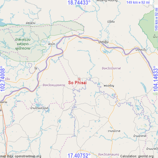
So Phisai GPS coordinates[2]
18° 4' 37.92" North, 103° 26' 35.52" East
| Map corner | latitude | longitude |
|---|---|---|
| Upper-left | 18.74433°, | 102.74008° |
| Center: | 18.0772°, | 103.4432° |
| Lower-right: | 17.40752°, | 104.14633° |
| Map W x H: | 148.6×148.6 km | = 92.3×92.3mi |
| max Lat: | 20.43353° ⇑10% North |
| So Phisai: | 18.0772° |
| min Lat: | ⇓90% South 5.77434° |
| min Long | So Phisai | max Long |
| 97.93288° | 103.4432° | 105.49506° |
| W 84.1%⇐ | ⇒15.9% E |
Elevation
Elevation of So Phisai is 173 m = 568 ft, and this is 47.5 m = 156 ft above average elevation for this country.
| Max E: |
1011 m = 3317 ft | 28.6% |
| So Phisai | 173 m 568 ft | |
| Avg. | 125.5 m = 412 ft | |
Min E: |
1 m = 3 ft | 71.4% |
See also: Thailand elevation on elevation.city.
Geographical zone
So Phisai is located in North Torrid zone (between Equator and Tropic of Cancer). Distance of this Northern Tropic circle is 595.9 km =370.3 mi to North.| Distance of | km | miles | from So Phisai |
|---|---|---|---|
| North Pole | 7997.1 | 4969.2 | to North |
| Arctic Circle | 5391.2 | 3349.9 | to North |
| Tropic Cancer | 595.9 | 370.3 | to North |
| Equator | 2010 | 1249 | to South |


Nearby cities:
15 places around So Phisai: (largest is in red/bold)
• Ban Dung
46.3 km =28.8 mi,  204°
204°
• Ban Muang
28.5 km =17.7 mi,  152°
152°
• Bueng Kan
38.7 km =24 mi,  34°
34°
• Charoen Sin
56.3 km =35 mi,  169°
169°
• Fao Rai
16.1 km =10 mi,  245°
245°
• Kham Ta Kla
41.5 km =25.8 mi,  127°
127°
• Pak Khat
29.3 km =18.2 mi,  329°
329°
• Pakkhat
28.5 km =17.7 mi, 329°
• Phon Charoen
28.7 km =17.8 mi,  100°
100°
• Phon Charoen
29.6 km =18.4 mi,  260°
260°
• Phon Phisai
39.3 km =24.4 mi, 260°
• Phonphisai
39.3 km =24.4 mi, 260°
• Rattanawapi
31.7 km =19.7 mi,  298°
298°
• Sang Khom
46.4 km =28.8 mi,  233°
233°
• Si Wilai
34.2 km =21.3 mi,  70°
70°
Sources, notices
• [Note1] Compared only with cities in Thailand existing in our database
• [Src1] Map data: © OpenStreetMap contributors (CC-BY-SA)
• [Src2] Other city data from geonames.org with taken over terms of usage.
• [Src3] Geographical zone / Annual Mean Temperature by Robert A. Rohde @ Wikipedia
