Chai Prakan geodata
Chai Prakan (Chiang Mai) is a seat of a second-order administrative division; located in Thailand in Asia/Bangkok (GMT+7) time zone. In our database, there are 331 cities with bigger population. Compared to other cities in Thailand, 98.4% of cities are located further ↓South; 90% of cities are located further →East and 98% of cities have lower elevation than Chai Prakan. Note1


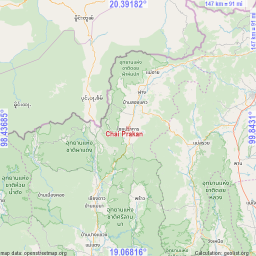
Chai Prakan GPS coordinates[2]
19° 43' 52.896" North, 99° 8' 23.892" East
| Map corner | latitude | longitude |
|---|---|---|
| Upper-left | 20.39182°, | 98.43685° |
| Center: | 19.73136°, | 99.13997° |
| Lower-right: | 19.06816°, | 99.8431° |
| Map W x H: | 147.2×147.2 km | = 91.5×91.5mi |
| max Lat: | 20.43353° ⇑1.6% North |
| Chai Prakan: | 19.73136° |
| min Lat: | ⇓98.4% South 5.77434° |
| min Long | Chai Prakan | max Long |
| 97.93288° | 99.13997° | 105.49506° |
| W 10%⇐ | ⇒90% E |
Elevation
Elevation of Chai Prakan is 501 m = 1644 ft, and this is 375.5 m = 1232 ft above average elevation for this country.
| Max E: |
1011 m = 3317 ft | 2% |
| Chai Prakan | 501 m 1644 ft | |
| Avg. | 125.5 m = 412 ft | |
Min E: |
1 m = 3 ft | 98% |
See also: Thailand elevation on elevation.city.
Geographical zone
Chai Prakan is located in North Torrid zone (between Equator and Tropic of Cancer). Distance of this Northern Tropic circle is 412 km =256 mi to North.| Distance of | km | miles | from Chai Prakan |
|---|---|---|---|
| North Pole | 7813.1 | 4854.8 | to North |
| Arctic Circle | 5207.3 | 3235.7 | to North |
| Tropic Cancer | 412 | 256 | to North |
| Equator | 2193.9 | 1363.2 | to South |


Nearby cities:
15 places around Chai Prakan: (largest is in red/bold)
• Ban Ho Mae Salong
70.7 km =43.9 mi,  46°
46°
• Chiang Dao
44.6 km =27.7 mi,  204°
204°
• Chiang Rai
75.1 km =46.7 mi,  74°
74°
• Fang
22.1 km =13.7 mi,  20°
20°
• Mae Ai
37 km =23 mi,  26°
26°
• Mae Chai
82.6 km =51.3 mi,  121°
121°
• Mae Lao
58.9 km =36.6 mi,  83°
83°
• Mae Suai
43.1 km =26.8 mi,  101°
101°
• Mae Taeng
71.4 km =44.4 mi, 196°
• Phan
65.9 km =40.9 mi,  107°
107°
• Phrao
41.2 km =25.6 mi,  170°
170°
• Wang Nuea
82.2 km =51.1 mi,  142°
142°
• Wiang Haeng
55.6 km =34.5 mi,  249°
249°
• Wiang Nuea
82.5 km =51.3 mi,  241°
241°
• Wiang Pa Pao
57.4 km =35.7 mi, 137°
Sources, notices
• [Note1] Compared only with cities in Thailand existing in our database
• [Src1] Map data: © OpenStreetMap contributors (CC-BY-SA)
• [Src2] Other city data from geonames.org with taken over terms of usage.
• [Src3] Geographical zone / Annual Mean Temperature by Robert A. Rohde @ Wikipedia
