Chaloem Phra Kiat geodata
Chaloem Phra Kiat (Nakhon Si Thammarat) is a seat of a second-order administrative division; located in Thailand in Asia/Bangkok (GMT+7) time zone. In our database, there are 331 cities with bigger population. Compared to other cities in Thailand, 88.2% of cities are located further ↑North; 71.5% of cities are located further →East and 99.3% of cities have higher elevation than Chaloem Phra Kiat. Note1


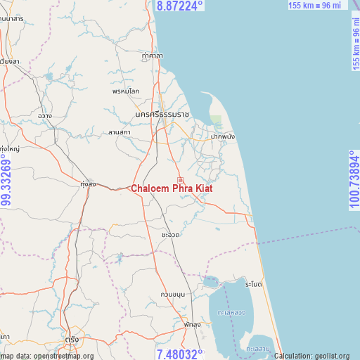
Chaloem Phra Kiat GPS coordinates[2]
8° 10' 36.804" North, 100° 2' 8.916" East
| Map corner | latitude | longitude |
|---|---|---|
| Upper-left | 8.87224°, | 99.33269° |
| Center: | 8.17689°, | 100.03581° |
| Lower-right: | 7.48032°, | 100.73894° |
| Map W x H: | 154.8×154.8 km | = 96.2×96.2mi |
| max Lat: | 20.43353° ⇑88.2% North |
| Chaloem Phra Kiat: | 8.17689° |
| min Lat: | ⇓11.8% South 5.77434° |
| min Long | Chaloem Phra Ki | max Long |
| 97.93288° | 100.03581° | 105.49506° |
| W 28.5%⇐ | ⇒71.5% E |
Elevation
Elevation of Chaloem Phra Kiat is 4 m = 13 ft, and this is 121.5 m = 399 ft below average elevation for this country.
| Max E: |
1011 m = 3317 ft | 99.3% |
| Avg. | 125.5 m = 412 ft | |
| Chaloem Phra Kiat | 4 m = 13 ft | |
Min E: |
1 m = 3 ft | 0.7% |
See also: Thailand elevation on elevation.city.
Geographical zone
Chaloem Phra Kiat is located in North Torrid zone (between Equator and Tropic of Cancer). Distance of Equator is 909.2 km =565 mi to South.| Distance of | km | miles | from Chaloem Phra Kiat |
|---|---|---|---|
| North Pole | 9097.9 | 5653.2 | to North |
| Arctic Circle | 6492 | 4033.9 | to North |
| Tropic Cancer | 1696.7 | 1054.3 | to North |
| Equator | 909.2 | 565 | to South |


Nearby cities:
15 places around Chaloem Phra Kiat: (largest is in red/bold)
• Cha-uat
23.6 km =14.7 mi,  189°
189°
• Chian Yai
12 km =7.5 mi,  93°
93°
• Chulabhorn
21.5 km =13.4 mi,  238°
238°
• Hua Sai
33.2 km =20.6 mi,  116°
116°
• Khuan Khanun
49.3 km =30.6 mi,  183°
183°
• Lan Saka
33.3 km =20.7 mi,  310°
310°
• Na Bon
49.4 km =30.7 mi,  280°
280°
• Nakhon Si Thammarat
29.5 km =18.3 mi,  345°
345°
• Pa Phayom
39.6 km =24.6 mi,  199°
199°
• Pak Phanang
26.6 km =16.5 mi,  43°
43°
• Phra Phrom
23.4 km =14.5 mi,  320°
320°
• Phrom Khiri
45.1 km =28 mi,  328°
328°
• Ratsada
49.7 km =30.9 mi, 243°
• Ron Phibun
20 km =12.4 mi,  270°
270°
• Thung Song
39.1 km =24.3 mi, 267°
Sources, notices
• [Note1] Compared only with cities in Thailand existing in our database
• [Src1] Map data: © OpenStreetMap contributors (CC-BY-SA)
• [Src2] Other city data from geonames.org with taken over terms of usage.
• [Src3] Geographical zone / Annual Mean Temperature by Robert A. Rohde @ Wikipedia
