Cha-uat geodata
Cha-uat (Nakhon Si Thammarat) is a seat of a second-order administrative division; located in Thailand in Asia/Bangkok (GMT+7) time zone. In our database, there are 331 cities with bigger population. Compared to other cities in Thailand, 89.7% of cities are located further ↑North; 72.4% of cities are located further →East and 83.5% of cities have higher elevation than Cha-uat. Note1


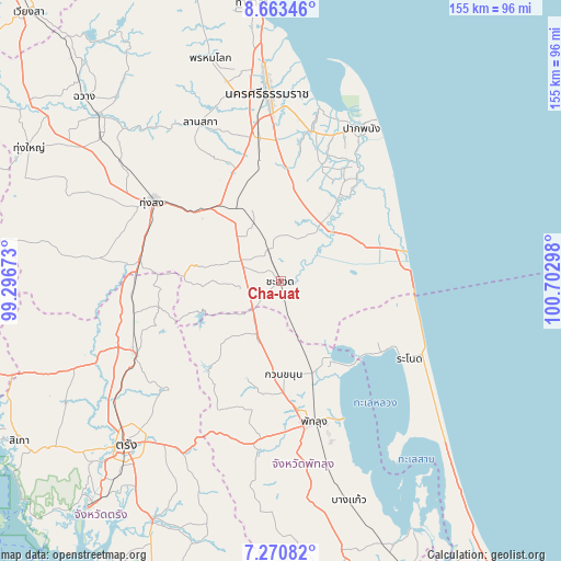
Cha-uat GPS coordinates[2]
7° 58' 3.828" North, 99° 59' 59.46" East
| Map corner | latitude | longitude |
|---|---|---|
| Upper-left | 8.66346°, | 99.29673° |
| Center: | 7.96773°, | 99.99985° |
| Lower-right: | 7.27082°, | 100.70298° |
| Map W x H: | 154.8×154.9 km | = 96.2×96.3mi |
| max Lat: | 20.43353° ⇑89.7% North |
| Cha-uat: | 7.96773° |
| min Lat: | ⇓10.3% South 5.77434° |
| min Long | Cha-uat | max Long |
| 97.93288° | 99.99985° | 105.49506° |
| W 27.6%⇐ | ⇒72.4% E |
Elevation
Elevation of Cha-uat is 11 m = 36 ft, and this is 114.5 m = 376 ft below average elevation for this country.
| Max E: |
1011 m = 3317 ft | 83.5% |
| Avg. | 125.5 m = 412 ft | |
| Cha-uat | 11 m = 36 ft | |
Min E: |
1 m = 3 ft | 16.5% |
See also: Thailand elevation on elevation.city.
Geographical zone
Cha-uat is located in North Torrid zone (between Equator and Tropic of Cancer). Distance of Equator is 885.9 km =550.5 mi to South.| Distance of | km | miles | from Cha-uat |
|---|---|---|---|
| North Pole | 9121.1 | 5667.6 | to North |
| Arctic Circle | 6515.2 | 4048.4 | to North |
| Tropic Cancer | 1720 | 1068.8 | to North |
| Equator | 885.9 | 550.5 | to South |


Nearby cities:
15 places around Cha-uat: (largest is in red/bold)
• Chaloem Phra Kiat
23.6 km =14.7 mi,  9°
9°
• Chian Yai
27.5 km =17.1 mi,  35°
35°
• Chulabhorn
18.7 km =11.6 mi,  309°
309°
• Hua Sai
34.7 km =21.6 mi,  75°
75°
• Huai Yot
44.8 km =27.8 mi,  243°
243°
• Khuan Khanun
25.9 km =16.1 mi,  177°
177°
• Pa Phayom
16.8 km =10.4 mi,  212°
212°
• Phatthalung
39.8 km =24.7 mi,  167°
167°
• Phra Phrom
42.7 km =26.5 mi,  345°
345°
• Ranot
41.2 km =25.6 mi,  120°
120°
• Ratsada
40.3 km =25 mi,  271°
271°
• Ron Phibun
28.4 km =17.6 mi,  325°
325°
• Si Banphot
30.2 km =18.8 mi,  204°
204°
• Srinagarindra
44.7 km =27.8 mi,  187°
187°
• Thung Song
41.4 km =25.7 mi,  301°
301°
Sources, notices
• [Note1] Compared only with cities in Thailand existing in our database
• [Src1] Map data: © OpenStreetMap contributors (CC-BY-SA)
• [Src2] Other city data from geonames.org with taken over terms of usage.
• [Src3] Geographical zone / Annual Mean Temperature by Robert A. Rohde @ Wikipedia
