Pa Phayom geodata
Pa Phayom (Phatthalung) is a seat of a second-order administrative division; located in Thailand in Asia/Bangkok (GMT+7) time zone. In our database, there are 331 cities with bigger population. Compared to other cities in Thailand, 91.1% of cities are located further ↑North; 75.3% of cities are located further →East and 65.8% of cities have higher elevation than Pa Phayom. Note1


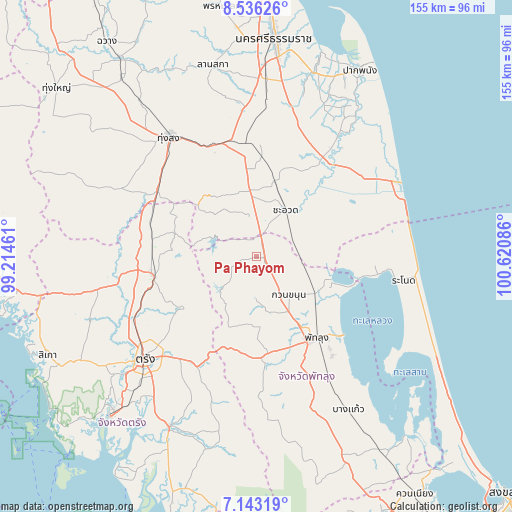
Pa Phayom GPS coordinates[2]
7° 50' 25.116" North, 99° 55' 3.828" East
| Map corner | latitude | longitude |
|---|---|---|
| Upper-left | 8.53626°, | 99.21461° |
| Center: | 7.84031°, | 99.91773° |
| Lower-right: | 7.14319°, | 100.62086° |
| Map W x H: | 154.9×154.9 km | = 96.3×96.3mi |
| max Lat: | 20.43353° ⇑91.1% North |
| Pa Phayom: | 7.84031° |
| min Lat: | ⇓8.9% South 5.77434° |
| min Long | Pa Phayom | max Long |
| 97.93288° | 99.91773° | 105.49506° |
| W 24.7%⇐ | ⇒75.3% E |
Elevation
Elevation of Pa Phayom is 30 m = 98 ft, and this is 95.5 m = 313 ft below average elevation for this country.
| Max E: |
1011 m = 3317 ft | 65.8% |
| Avg. | 125.5 m = 412 ft | |
| Pa Phayom | 30 m = 98 ft | |
Min E: |
1 m = 3 ft | 34.2% |
See also: Thailand elevation on elevation.city.
Geographical zone
Pa Phayom is located in North Torrid zone (between Equator and Tropic of Cancer). Distance of Equator is 871.8 km =541.7 mi to South.| Distance of | km | miles | from Pa Phayom |
|---|---|---|---|
| North Pole | 9135.3 | 5676.4 | to North |
| Arctic Circle | 6529.4 | 4057.2 | to North |
| Tropic Cancer | 1734.2 | 1077.6 | to North |
| Equator | 871.8 | 541.7 | to South |


Nearby cities:
15 places around Pa Phayom: (largest is in red/bold)
• Cha-uat
16.8 km =10.4 mi,  32°
32°
• Chaloem Phra Kiat
39.6 km =24.6 mi,  19°
19°
• Chian Yai
44.3 km =27.5 mi, 34°
• Chulabhorn
26.7 km =16.6 mi,  348°
348°
• Huai Yot
31.7 km =19.7 mi,  259°
259°
• Khuan Khanun
15.5 km =9.6 mi,  139°
139°
• Na Yong
39.5 km =24.5 mi,  218°
218°
• Phatthalung
30.4 km =18.9 mi, 144°
• Ranot
45 km =28 mi,  98°
98°
• Ratsada
34.7 km =21.6 mi,  295°
295°
• Ron Phibun
38.3 km =23.8 mi, 349°
• Si Banphot
13.7 km =8.5 mi,  195°
195°
• Srinagarindra
30.2 km =18.8 mi,  174°
174°
• Thung Song
44.5 km =27.7 mi,  324°
324°
• Trang
46.2 km =28.7 mi,  226°
226°
Sources, notices
• [Note1] Compared only with cities in Thailand existing in our database
• [Src1] Map data: © OpenStreetMap contributors (CC-BY-SA)
• [Src2] Other city data from geonames.org with taken over terms of usage.
• [Src3] Geographical zone / Annual Mean Temperature by Robert A. Rohde @ Wikipedia
