Lao Khwan geodata
Lao Khwan (Kanchanaburi) is a seat of a second-order administrative division; located in Thailand in Asia/Bangkok (GMT+7) time zone. In our database, there are 331 cities with bigger population. Compared to other cities in Thailand, 57.9% of cities are located further ↑North; 79.7% of cities are located further →East and 60.5% of cities have higher elevation than Lao Khwan. Note1


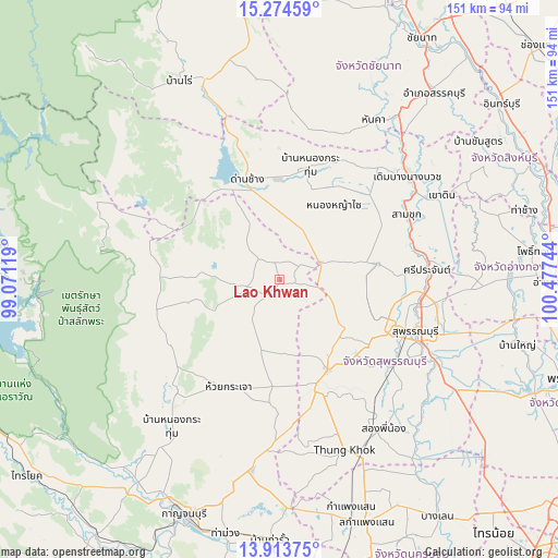
Lao Khwan GPS coordinates[2]
14° 35' 42.792" North, 99° 46' 27.516" East
| Map corner | latitude | longitude |
|---|---|---|
| Upper-left | 15.27459°, | 99.07119° |
| Center: | 14.59522°, | 99.77431° |
| Lower-right: | 13.91375°, | 100.47744° |
| Map W x H: | 151.3×151.3 km | = 94×94mi |
| max Lat: | 20.43353° ⇑57.9% North |
| Lao Khwan: | 14.59522° |
| min Lat: | ⇓42.1% South 5.77434° |
| min Long | Lao Khwan | max Long |
| 97.93288° | 99.77431° | 105.49506° |
| W 20.3%⇐ | ⇒79.7% E |
Elevation
Elevation of Lao Khwan is 43 m = 141 ft, and this is 82.5 m = 271 ft below average elevation for this country.
| Max E: |
1011 m = 3317 ft | 60.5% |
| Avg. | 125.5 m = 412 ft | |
| Lao Khwan | 43 m = 141 ft | |
Min E: |
1 m = 3 ft | 39.5% |
See also: Thailand elevation on elevation.city.
Geographical zone
Lao Khwan is located in North Torrid zone (between Equator and Tropic of Cancer). Distance of this Northern Tropic circle is 983.1 km =610.9 mi to North.| Distance of | km | miles | from Lao Khwan |
|---|---|---|---|
| North Pole | 8384.2 | 5209.7 | to North |
| Arctic Circle | 5778.3 | 3590.5 | to North |
| Tropic Cancer | 983.1 | 610.9 | to North |
| Equator | 1622.8 | 1008.4 | to South |


Nearby cities:
15 places around Lao Khwan: (largest is in red/bold)
• Ban Sam Chuk
38.2 km =23.7 mi,  64°
64°
• Bang Pla Ma
46.9 km =29.1 mi,  118°
118°
• Bo Phloi
41 km =25.5 mi,  222°
222°
• Dan Chang
28.6 km =17.8 mi,  343°
343°
• Doem Bang Nang Buat
45.2 km =28.1 mi,  50°
50°
• Doembang Nangbuat
43.9 km =27.3 mi, 52°
• Don Chedi
26.9 km =16.7 mi,  80°
80°
• Huai Krachao
31.9 km =19.8 mi,  201°
201°
• Noen Kham
43.2 km =26.8 mi,  24°
24°
• Nong Prue
34.1 km =21.2 mi,  272°
272°
• Nong Yasai
25.2 km =15.7 mi,  35°
35°
• Sam Chuk
38.5 km =23.9 mi, 61°
• Si Prachan
40 km =24.9 mi,  86°
86°
• Suphan Buri
39.8 km =24.7 mi,  109°
109°
• U Thong
27.6 km =17.1 mi,  152°
152°
Sources, notices
• [Note1] Compared only with cities in Thailand existing in our database
• [Src1] Map data: © OpenStreetMap contributors (CC-BY-SA)
• [Src2] Other city data from geonames.org with taken over terms of usage.
• [Src3] Geographical zone / Annual Mean Temperature by Robert A. Rohde @ Wikipedia
