Ban Dan Lan Hoi geodata
Ban Dan Lan Hoi (Sukhothai) is a seat of a second-order administrative division; located in Thailand in Asia/Bangkok (GMT+7) time zone. With population of 5,791 people, there are 306 cities with bigger population in this country. Compared to other cities in Thailand, 78.5% of cities are located further ↓South; 83.8% of cities are located further →East and 50.5% of cities have higher elevation than Ban Dan Lan Hoi. Note1


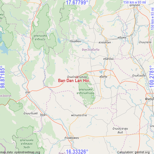
Ban Dan Lan Hoi GPS coordinates[2]
17° 0' 24.588" North, 99° 34' 29.892" East
| Map corner | latitude | longitude |
|---|---|---|
| Upper-left | 17.67799°, | 98.87185° |
| Center: | 17.00683°, | 99.57497° |
| Lower-right: | 16.33326°, | 100.2781° |
| Map W x H: | 149.5×149.5 km | = 92.9×92.9mi |
| max Lat: | 20.43353° ⇑21.5% North |
| Ban Dan Lan Hoi: | 17.00683° |
| min Lat: | ⇓78.5% South 5.77434° |
| min Long | Ban Dan Lan Hoi | max Long |
| 97.93288° | 99.57497° | 105.49506° |
| W 16.2%⇐ | ⇒83.8% E |
Elevation
Elevation of Ban Dan Lan Hoi is 87 m = 285 ft, and this is 38.5 m = 126 ft below average elevation for this country.
| Max E: |
1011 m = 3317 ft | 50.5% |
| Avg. | 125.5 m = 412 ft | |
| Ban Dan Lan Hoi | 87 m = 285 ft | |
Min E: |
1 m = 3 ft | 49.5% |
See also: Thailand elevation on elevation.city.
Geographical zone
Ban Dan Lan Hoi is located in North Torrid zone (between Equator and Tropic of Cancer). Distance of this Northern Tropic circle is 714.9 km =444.2 mi to North.| Distance of | km | miles | from Ban Dan Lan Hoi |
|---|---|---|---|
| North Pole | 8116.1 | 5043.1 | to North |
| Arctic Circle | 5510.2 | 3423.9 | to North |
| Tropic Cancer | 714.9 | 444.2 | to North |
| Equator | 1891 | 1175 | to South |


Nearby cities:
15 places around Ban Dan Lan Hoi: (largest is in red/bold)
• Ban Na
16.8 km =10.4 mi,  86°
86°
• Ban Tak
52.6 km =32.7 mi,  274°
274°
• Kamphaeng Phet
58.5 km =36.4 mi,  185°
185°
• Khiri Mat
30.7 km =19.1 mi,  128°
128°
• Kong Krailat
43.3 km =26.9 mi,  98°
98°
• Kosamphi Nakhon
48.1 km =29.9 mi,  209°
209°
• Lan Krabue
53.8 km =33.4 mi,  147°
147°
• Phran Kratai
38 km =23.6 mi,  177°
177°
• Sawankhalok
43.9 km =27.3 mi,  38°
38°
• Si Nakhon
57.9 km =36 mi,  48°
48°
• Si Samrong
35.2 km =21.9 mi,  60°
60°
• Sukhothai
26.4 km =16.4 mi, 89°
• Tak
49.8 km =30.9 mi,  252°
252°
• Thung Saliam
35 km =21.7 mi,  357°
357°
• Wang Chao
49.3 km =30.6 mi,  221°
221°
Sources, notices
• [Note1] Compared only with cities in Thailand existing in our database
• [Src1] Map data: © OpenStreetMap contributors (CC-BY-SA)
• [Src2] Other city data from geonames.org with taken over terms of usage.
• [Src3] Geographical zone / Annual Mean Temperature by Robert A. Rohde @ Wikipedia
