Wang Chao geodata
Wang Chao (Tak) is a seat of a second-order administrative division; located in Thailand in Asia/Bangkok (GMT+7) time zone. In our database, there are 331 cities with bigger population. Compared to other cities in Thailand, 74.4% of cities are located further ↓South; 88.2% of cities are located further →East and 50.6% of cities have lower elevation than Wang Chao. Note1


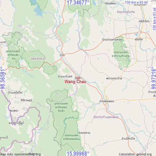
Wang Chao GPS coordinates[2]
16° 40' 27.876" North, 99° 16' 8.508" East
| Map corner | latitude | longitude |
|---|---|---|
| Upper-left | 17.34677°, | 98.56591° |
| Center: | 16.67441°, | 99.26903° |
| Lower-right: | 15.99968°, | 99.97216° |
| Map W x H: | 149.8×149.8 km | = 93.1×93.1mi |
| max Lat: | 20.43353° ⇑25.6% North |
| Wang Chao: | 16.67441° |
| min Lat: | ⇓74.4% South 5.77434° |
| min Long | Wang Chao | max Long |
| 97.93288° | 99.26903° | 105.49506° |
| W 11.8%⇐ | ⇒88.2% E |
Elevation
Elevation of Wang Chao is 105 m = 344 ft, and this is 20.5 m = 67 ft below average elevation for this country.
| Max E: |
1011 m = 3317 ft | 49.4% |
| Avg. | 125.5 m = 412 ft | |
| Wang Chao | 105 m = 344 ft | |
Min E: |
1 m = 3 ft | 50.6% |
See also: Thailand elevation on elevation.city.
Geographical zone
Wang Chao is located in North Torrid zone (between Equator and Tropic of Cancer). Distance of this Northern Tropic circle is 751.9 km =467.2 mi to North.| Distance of | km | miles | from Wang Chao |
|---|---|---|---|
| North Pole | 8153 | 5066 | to North |
| Arctic Circle | 5547.2 | 3446.9 | to North |
| Tropic Cancer | 751.9 | 467.2 | to North |
| Equator | 1854 | 1152 | to South |


Nearby cities:
15 places around Wang Chao: (largest is in red/bold)
• Ban Dan Lan Hoi
49.3 km =30.6 mi,  41°
41°
• Ban Na
62.4 km =38.8 mi,  52°
52°
• Ban Tak
45.6 km =28.3 mi,  334°
334°
• Kamphaeng Phet
34.3 km =21.3 mi,  128°
128°
• Khiri Mat
59.2 km =36.8 mi,  72°
72°
• Khlong Lan
52.7 km =32.7 mi,  174°
174°
• Kosamphi Nakhon
9.8 km =6.1 mi,  119°
119°
• Lan Krabue
62.3 km =38.7 mi,  97°
97°
• Pang Sila Thong
68.4 km =42.5 mi,  159°
159°
• Phop Phra
69.6 km =43.2 mi,  242°
242°
• Phran Kratai
34.1 km =21.2 mi,  91°
91°
• Sai Ngam
69.9 km =43.4 mi,  109°
109°
• Sam Ngao
68.5 km =42.6 mi,  337°
337°
• Sukhothai
69.6 km =43.2 mi,  57°
57°
• Tak
26.3 km =16.3 mi, 325°
Sources, notices
• [Note1] Compared only with cities in Thailand existing in our database
• [Src1] Map data: © OpenStreetMap contributors (CC-BY-SA)
• [Src2] Other city data from geonames.org with taken over terms of usage.
• [Src3] Geographical zone / Annual Mean Temperature by Robert A. Rohde @ Wikipedia
