Pak Chong geodata
Pak Chong (Nakhon Ratchasima) is a seat of a second-order administrative division; located in Thailand in Asia/Bangkok (GMT+7) time zone. With population of 48,999 people, there are 58 cities with bigger population in this country. Compared to other cities in Thailand, 55.6% of cities are located further ↑North; 60.3% of cities are located further ←West and 91.9% of cities have lower elevation than Pak Chong. Note1


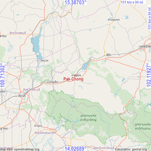
Pak Chong GPS coordinates[2]
14° 42' 28.872" North, 101° 24' 58.104" East
| Map corner | latitude | longitude |
|---|---|---|
| Upper-left | 15.38703°, | 100.71302° |
| Center: | 14.70802°, | 101.41614° |
| Lower-right: | 14.02689°, | 102.11927° |
| Map W x H: | 151.2×151.2 km | = 94×94mi |
| max Lat: | 20.43353° ⇑55.6% North |
| Pak Chong: | 14.70802° |
| min Lat: | ⇓44.4% South 5.77434° |
| min Long | Pak Chong | max Long |
| 97.93288° | 101.41614° | 105.49506° |
| W 60.3%⇐ | ⇒39.7% E |
Elevation
Elevation of Pak Chong is 307 m = 1007 ft, and this is 181.5 m = 595 ft above average elevation for this country.
| Max E: |
1011 m = 3317 ft | 8.1% |
| Pak Chong | 307 m 1007 ft | |
| Avg. | 125.5 m = 412 ft | |
Min E: |
1 m = 3 ft | 91.9% |
See also: Pak Chong elevation on elevation.city.
Geographical zone
Pak Chong is located in North Torrid zone (between Equator and Tropic of Cancer). Distance of this Northern Tropic circle is 970.5 km =603 mi to North.| Distance of | km | miles | from Pak Chong |
|---|---|---|---|
| North Pole | 8371.7 | 5201.9 | to North |
| Arctic Circle | 5765.8 | 3582.7 | to North |
| Tropic Cancer | 970.5 | 603 | to North |
| Equator | 1635.4 | 1016.2 | to South |


Nearby cities:
15 places around Pak Chong: (largest is in red/bold)
• Amphoe Sikhiu
37.9 km =23.5 mi,  55°
55°
• Ban Na
61.9 km =38.5 mi,  216°
216°
• Chaloem Phra Kiat
55.7 km =34.6 mi,  258°
258°
• Kaeng Khoi
47 km =29.2 mi,  253°
253°
• Muak Lek
24 km =14.9 mi, 255°
• Nakhon Nayok
60.1 km =37.3 mi,  201°
201°
• Pak Phli
62.6 km =38.9 mi,  194°
194°
• Phatthana Nikhom
49.2 km =30.6 mi,  289°
289°
• Saraburi
57.1 km =35.5 mi, 250°
• Sikhio
38.8 km =24.1 mi, 58°
• Sung Noen
48.4 km =30.1 mi, 63°
• Tha Luang
52.9 km =32.9 mi,  319°
319°
• Wang Muang
34.6 km =21.5 mi,  295°
295°
• Wang Nam Khiao
57.7 km =35.9 mi,  123°
123°
• Wihan Daeng
61.1 km =38 mi,  228°
228°
Sources, notices
• [Note1] Compared only with cities in Thailand existing in our database
• [Src1] Map data: © OpenStreetMap contributors (CC-BY-SA)
• [Src2] Other city data from geonames.org with taken over terms of usage.
• [Src3] Geographical zone / Annual Mean Temperature by Robert A. Rohde @ Wikipedia
