Thepharak geodata
Thepharak (Nakhon Ratchasima) is a seat of a second-order administrative division; located in Thailand in Asia/Bangkok (GMT+7) time zone. In our database, there are 331 cities with bigger population. Compared to other cities in Thailand, 54.9% of cities are located further ↓South; 62% of cities are located further ←West and 90.3% of cities have lower elevation than Thepharak. Note1


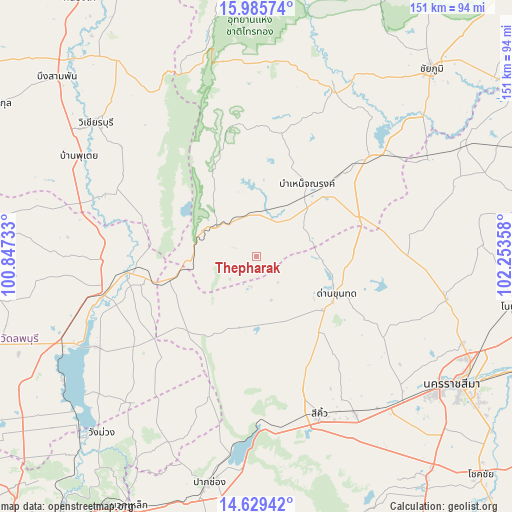
Thepharak GPS coordinates[2]
15° 18' 31.248" North, 101° 33' 1.62" East
| Map corner | latitude | longitude |
|---|---|---|
| Upper-left | 15.98574°, | 100.84733° |
| Center: | 15.30868°, | 101.55045° |
| Lower-right: | 14.62942°, | 102.25358° |
| Map W x H: | 150.8×150.8 km | = 93.7×93.7mi |
| max Lat: | 20.43353° ⇑45.1% North |
| Thepharak: | 15.30868° |
| min Lat: | ⇓54.9% South 5.77434° |
| min Long | Thepharak | max Long |
| 97.93288° | 101.55045° | 105.49506° |
| W 62%⇐ | ⇒38% E |
Elevation
Elevation of Thepharak is 282 m = 925 ft, and this is 156.5 m = 513 ft above average elevation for this country.
| Max E: |
1011 m = 3317 ft | 9.7% |
| Thepharak | 282 m 925 ft | |
| Avg. | 125.5 m = 412 ft | |
Min E: |
1 m = 3 ft | 90.3% |
See also: Thailand elevation on elevation.city.
Geographical zone
Thepharak is located in North Torrid zone (between Equator and Tropic of Cancer). Distance of this Northern Tropic circle is 903.8 km =561.6 mi to North.| Distance of | km | miles | from Thepharak |
|---|---|---|---|
| North Pole | 8304.9 | 5160.4 | to North |
| Arctic Circle | 5699 | 3541.2 | to North |
| Tropic Cancer | 903.8 | 561.6 | to North |
| Equator | 1702.2 | 1057.7 | to South |


Nearby cities:
15 places around Thepharak: (largest is in red/bold)
• Amphoe Sikhiu
48.6 km =30.2 mi,  159°
159°
• Bamnet Narong
26.2 km =16.3 mi,  34°
34°
• Chai Badan
46.3 km =28.8 mi,  254°
254°
• Chatturat
42.6 km =26.5 mi,  47°
47°
• Dan Khun Thot
26.2 km =16.3 mi,  115°
115°
• Lam Sonthi
20 km =12.4 mi,  267°
267°
• Noen Sa-nga
56.1 km =34.9 mi,  59°
59°
• Nong Bua Rawe
54.5 km =33.9 mi,  24°
24°
• Phra Thong Kham
50.6 km =31.4 mi,  95°
95°
• Sap Yai
37.2 km =23.1 mi,  10°
10°
• Si Thep
54.3 km =33.7 mi,  287°
287°
• Sikhio
49.9 km =31 mi, 158°
• Sung Noen
54 km =33.6 mi,  147°
147°
• Tha Luang
55.3 km =34.4 mi,  241°
241°
• Thep Sathit
14.2 km =8.8 mi,  311°
311°
Sources, notices
• [Note1] Compared only with cities in Thailand existing in our database
• [Src1] Map data: © OpenStreetMap contributors (CC-BY-SA)
• [Src2] Other city data from geonames.org with taken over terms of usage.
• [Src3] Geographical zone / Annual Mean Temperature by Robert A. Rohde @ Wikipedia
