Samut Prakan geodata
Samut Prakan is a seat of a first-order administrative division; located in Thailand in Asia/Bangkok (GMT+7) time zone. With population of 388,920 people, there is 1 city with bigger population in this country. Compared to other cities in Thailand, 73.9% of cities are located further ↑North; 53.9% of cities are located further →East and 98% of cities have higher elevation than Samut Prakan. Note1


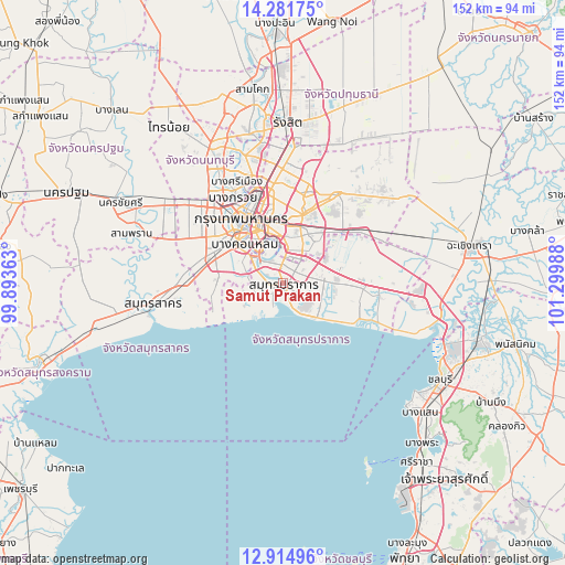
Samut Prakan GPS coordinates[2]
13° 35' 57.624" North, 100° 35' 48.3" East
| Map corner | latitude | longitude |
|---|---|---|
| Upper-left | 14.28175°, | 99.89363° |
| Center: | 13.59934°, | 100.59675° |
| Lower-right: | 12.91496°, | 101.29988° |
| Map W x H: | 152×152 km | = 94.4×94.4mi |
| max Lat: | 20.43353° ⇑73.9% North |
| Samut Prakan: | 13.59934° |
| min Lat: | ⇓26.1% South 5.77434° |
| min Long | Samut Prakan | max Long |
| 97.93288° | 100.59675° | 105.49506° |
| W 46.1%⇐ | ⇒53.9% E |
Elevation
Elevation of Samut Prakan is 5 m = 16 ft, and this is 120.5 m = 395 ft below average elevation for this country.
| Max E: |
1011 m = 3317 ft | 98% |
| Avg. | 125.5 m = 412 ft | |
| Samut Prakan | 5 m = 16 ft | |
Min E: |
1 m = 3 ft | 2% |
See also: Samut Prakan elevation on elevation.city.
Geographical zone
Samut Prakan is located in North Torrid zone (between Equator and Tropic of Cancer). Distance of this Northern Tropic circle is 1093.8 km =679.7 mi to North.| Distance of | km | miles | from Samut Prakan |
|---|---|---|---|
| North Pole | 8495 | 5278.5 | to North |
| Arctic Circle | 5889.1 | 3659.3 | to North |
| Tropic Cancer | 1093.8 | 679.7 | to North |
| Equator | 1512.1 | 939.6 | to South |


Nearby cities:
15 places around Samut Prakan: (largest is in red/bold)
• Bang Kho Laem
14.6 km =9.1 mi,  315°
315°
• Bang Na
9 km =5.6 mi,  32°
32°
• Bang Rak
16.6 km =10.3 mi,  331°
331°
• Chom Thong
14.9 km =9.3 mi,  305°
305°
• Khlong Toei
13.3 km =8.3 mi,  348°
348°
• Phra Khanong
11.4 km =7.1 mi,  2°
2°
• Phra Pradaeng
9.5 km =5.9 mi, 313°
• Phra Samut Chedi
2.7 km =1.7 mi,  276°
276°
• Rat Burana
13.5 km =8.4 mi, 313°
• Samphanthawong
17.2 km =10.7 mi, 328°
• Sathon
14.3 km =8.9 mi, 327°
• Suan Luang
15.7 km =9.8 mi,  22°
22°
• Thung Khru
10 km =6.2 mi,  289°
289°
• Watthana
14.6 km =9.1 mi,  355°
355°
• Yan Nawa
12.3 km =7.6 mi, 331°
Sources, notices
• [Note1] Compared only with cities in Thailand existing in our database
• [Src1] Map data: © OpenStreetMap contributors (CC-BY-SA)
• [Src2] Other city data from geonames.org with taken over terms of usage.
• [Src3] Geographical zone / Annual Mean Temperature by Robert A. Rohde @ Wikipedia
