Ngao geodata
Ngao (Lampang) is a seat of a second-order administrative division; located in Thailand in Asia/Bangkok (GMT+7) time zone. In our database, there are 331 cities with bigger population. Compared to other cities in Thailand, 94.1% of cities are located further ↓South; 73.2% of cities are located further →East and 90.5% of cities have lower elevation than Ngao. Note1


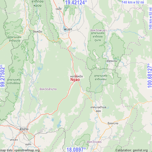
Ngao GPS coordinates[2]
18° 45' 24.408" North, 99° 58' 41.304" East
| Map corner | latitude | longitude |
|---|---|---|
| Upper-left | 19.42124°, | 99.27502° |
| Center: | 18.75678°, | 99.97814° |
| Lower-right: | 18.0897°, | 100.68127° |
| Map W x H: | 148.1×148.1 km | = 92×92mi |
| max Lat: | 20.43353° ⇑5.9% North |
| Ngao: | 18.75678° |
| min Lat: | ⇓94.1% South 5.77434° |
| min Long | Ngao | max Long |
| 97.93288° | 99.97814° | 105.49506° |
| W 26.8%⇐ | ⇒73.2% E |
Elevation
Elevation of Ngao is 283 m = 928 ft, and this is 157.5 m = 517 ft above average elevation for this country.
| Max E: |
1011 m = 3317 ft | 9.5% |
| Ngao | 283 m 928 ft | |
| Avg. | 125.5 m = 412 ft | |
Min E: |
1 m = 3 ft | 90.5% |
See also: Thailand elevation on elevation.city.
Geographical zone
Ngao is located in North Torrid zone (between Equator and Tropic of Cancer). Distance of this Northern Tropic circle is 520.4 km =323.4 mi to North.| Distance of | km | miles | from Ngao |
|---|---|---|---|
| North Pole | 7921.5 | 4922.2 | to North |
| Arctic Circle | 5315.6 | 3303 | to North |
| Tropic Cancer | 520.4 | 323.4 | to North |
| Equator | 2085.6 | 1295.9 | to South |


Nearby cities:
15 places around Ngao: (largest is in red/bold)
• Ban Luang
49.4 km =30.7 mi,  77°
77°
• Chae Hom
44.6 km =27.7 mi,  263°
263°
• Chiang Muan
37.5 km =23.3 mi,  66°
66°
• Chun
66.6 km =41.4 mi,  14°
14°
• Dok Kham Tai
45.1 km =28 mi,  2°
2°
• Mae Chai
67.7 km =42.1 mi,  345°
345°
• Mae Mo
63.7 km =39.6 mi,  212°
212°
• Mueang Pan
50.1 km =31.1 mi,  271°
271°
• Nong Muang Khai
59.1 km =36.7 mi,  157°
157°
• Phayao
49.5 km =30.8 mi, 347°
• Phu Kam Yao
57.1 km =35.5 mi,  359°
359°
• Pong
53.7 km =33.4 mi,  35°
35°
• Rong Kwang
58.6 km =36.4 mi,  142°
142°
• Song
38.3 km =23.8 mi,  145°
145°
• Wang Nuea
57.5 km =35.7 mi,  318°
318°
Sources, notices
• [Note1] Compared only with cities in Thailand existing in our database
• [Src1] Map data: © OpenStreetMap contributors (CC-BY-SA)
• [Src2] Other city data from geonames.org with taken over terms of usage.
• [Src3] Geographical zone / Annual Mean Temperature by Robert A. Rohde @ Wikipedia
