Phayao geodata
Phayao is a seat of a first-order administrative division; located in Thailand in Asia/Bangkok (GMT+7) time zone. With population of 21,058 people, there are 151 cities with bigger population in this country. Compared to other cities in Thailand, 96% of cities are located further ↓South; 76.5% of cities are located further →East and 96.2% of cities have lower elevation than Phayao. Note1


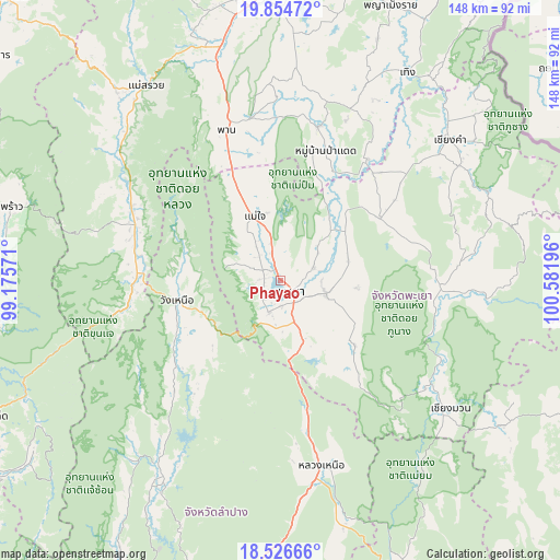
Phayao GPS coordinates[2]
19° 11' 31.308" North, 99° 52' 43.788" East
| Map corner | latitude | longitude |
|---|---|---|
| Upper-left | 19.85472°, | 99.17571° |
| Center: | 19.19203°, | 99.87883° |
| Lower-right: | 18.52666°, | 100.58196° |
| Map W x H: | 147.7×147.7 km | = 91.8×91.8mi |
| max Lat: | 20.43353° ⇑4% North |
| Phayao: | 19.19203° |
| min Lat: | ⇓96% South 5.77434° |
| min Long | Phayao | max Long |
| 97.93288° | 99.87883° | 105.49506° |
| W 23.5%⇐ | ⇒76.5% E |
Elevation
Elevation of Phayao is 409 m = 1342 ft, and this is 283.5 m = 930 ft above average elevation for this country.
| Max E: |
1011 m = 3317 ft | 3.8% |
| Phayao | 409 m 1342 ft | |
| Avg. | 125.5 m = 412 ft | |
Min E: |
1 m = 3 ft | 96.2% |
See also: Thailand elevation on elevation.city.
Geographical zone
Phayao is located in North Torrid zone (between Equator and Tropic of Cancer). Distance of this Northern Tropic circle is 472 km =293.3 mi to North.| Distance of | km | miles | from Phayao |
|---|---|---|---|
| North Pole | 7873.1 | 4892.1 | to North |
| Arctic Circle | 5267.2 | 3272.9 | to North |
| Tropic Cancer | 472 | 293.3 | to North |
| Equator | 2134 | 1326 | to South |


Nearby cities:
15 places around Phayao: (largest is in red/bold)
• Chae Hom
63.1 km =39.2 mi,  212°
212°
• Chiang Kham
57.5 km =35.7 mi,  50°
50°
• Chiang Muan
56.1 km =34.9 mi,  126°
126°
• Chun
31.3 km =19.4 mi,  59°
59°
• Dok Kham Tai
12.5 km =7.8 mi,  105°
105°
• Mae Chai
18.4 km =11.4 mi,  338°
338°
• Mae Suai
62.5 km =38.8 mi,  325°
325°
• Mueang Pan
61.5 km =38.2 mi,  220°
220°
• Ngao
49.5 km =30.8 mi,  167°
167°
• Pa Daet
36.8 km =22.9 mi,  18°
18°
• Phan
42.8 km =26.6 mi, 340°
• Phu Kam Yao
13 km =8.1 mi, 47°
• Pong
41.9 km =26 mi,  96°
96°
• Wang Nuea
27.7 km =17.2 mi,  259°
259°
• Wiang Pa Pao
42.7 km =26.5 mi,  293°
293°
Sources, notices
• [Note1] Compared only with cities in Thailand existing in our database
• [Src1] Map data: © OpenStreetMap contributors (CC-BY-SA)
• [Src2] Other city data from geonames.org with taken over terms of usage.
• [Src3] Geographical zone / Annual Mean Temperature by Robert A. Rohde @ Wikipedia
