Phetchabun geodata
Phetchabun is a seat of a first-order administrative division; located in Thailand in Asia/Bangkok (GMT+7) time zone. With population of 50,656 people, there are 53 cities with bigger population in this country. Compared to other cities in Thailand, 71.1% of cities are located further ↓South; 56.9% of cities are located further ←West and 51.9% of cities have lower elevation than Phetchabun. Note1


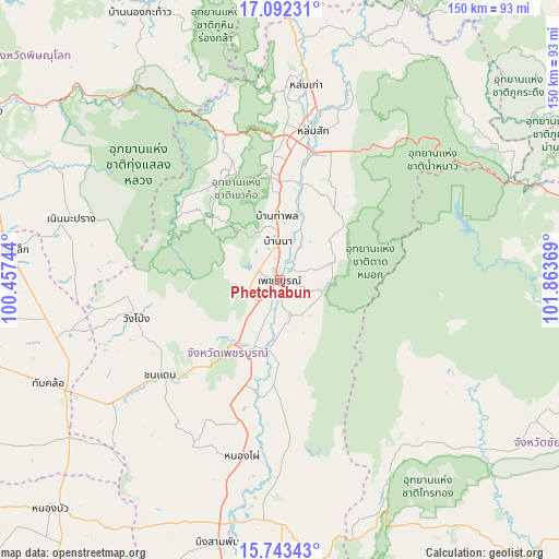
Phetchabun GPS coordinates[2]
16° 25' 8.544" North, 101° 9' 38.016" East
| Map corner | latitude | longitude |
|---|---|---|
| Upper-left | 17.09231°, | 100.45744° |
| Center: | 16.41904°, | 101.16056° |
| Lower-right: | 15.74343°, | 101.86369° |
| Map W x H: | 150×150 km | = 93.2×93.2mi |
| max Lat: | 20.43353° ⇑28.9% North |
| Phetchabun: | 16.41904° |
| min Lat: | ⇓71.1% South 5.77434° |
| min Long | Phetchabun | max Long |
| 97.93288° | 101.16056° | 105.49506° |
| W 56.9%⇐ | ⇒43.1% E |
Elevation
Elevation of Phetchabun is 120 m = 394 ft, and this is 5.5 m = 18 ft below average elevation for this country.
| Max E: |
1011 m = 3317 ft | 48.1% |
| Avg. | 125.5 m = 412 ft | |
| Phetchabun | 120 m = 394 ft | |
Min E: |
1 m = 3 ft | 51.9% |
See also: Phetchabun elevation on elevation.city.
Geographical zone
Phetchabun is located in North Torrid zone (between Equator and Tropic of Cancer). Distance of this Northern Tropic circle is 780.3 km =484.9 mi to North.| Distance of | km | miles | from Phetchabun |
|---|---|---|---|
| North Pole | 8181.4 | 5083.7 | to North |
| Arctic Circle | 5575.5 | 3464.5 | to North |
| Tropic Cancer | 780.3 | 484.9 | to North |
| Equator | 1825.6 | 1134.4 | to South |


Nearby cities:
15 places around Phetchabun: (largest is in red/bold)
• Bueng Sam Phan
70.4 km =43.7 mi,  201°
201°
• Chon Daen
41 km =25.5 mi,  231°
231°
• Dong Charoen
69.2 km =43 mi, 230°
• Khao Kho
30.4 km =18.9 mi,  330°
330°
• Lom Kao
52.4 km =32.6 mi,  7°
7°
• Lom Sak
41 km =25.5 mi, 12°
• Nam Nao
66.6 km =41.4 mi,  54°
54°
• Noen Maprang
58.6 km =36.4 mi,  286°
286°
• Nong Bua Daeng
78.2 km =48.6 mi,  118°
118°
• Nong Phai
48.8 km =30.3 mi,  192°
192°
• Phakdi Chumphon
63.6 km =39.5 mi,  153°
153°
• Sak Lek
74.1 km =46 mi,  277°
277°
• Thap Khlo
66.7 km =41.4 mi,  244°
244°
• Wang Pong
40.1 km =24.9 mi,  257°
257°
• Wang Sai Phun
66.5 km =41.3 mi,  267°
267°
Sources, notices
• [Note1] Compared only with cities in Thailand existing in our database
• [Src1] Map data: © OpenStreetMap contributors (CC-BY-SA)
• [Src2] Other city data from geonames.org with taken over terms of usage.
• [Src3] Geographical zone / Annual Mean Temperature by Robert A. Rohde @ Wikipedia
