Phakdi Chumphon geodata
Phakdi Chumphon (Chaiyaphum) is a seat of a second-order administrative division; located in Thailand in Asia/Bangkok (GMT+7) time zone. In our database, there are 331 cities with bigger population. Compared to other cities in Thailand, 64.4% of cities are located further ↓South; 60.5% of cities are located further ←West and 89.8% of cities have lower elevation than Phakdi Chumphon. Note1


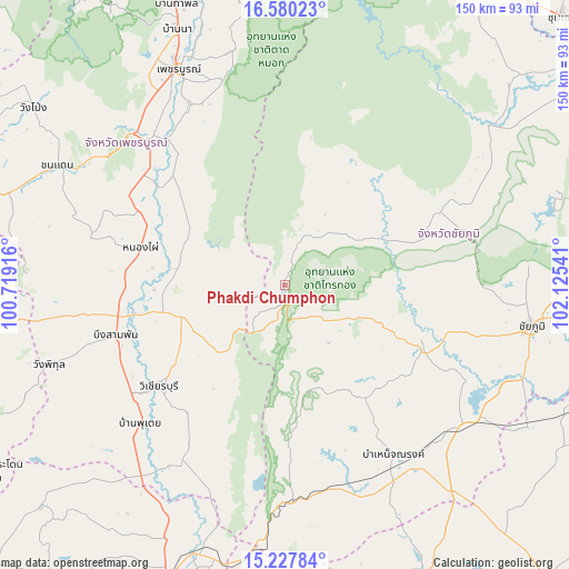
Phakdi Chumphon GPS coordinates[2]
15° 54' 18.612" North, 101° 25' 20.208" East
| Map corner | latitude | longitude |
|---|---|---|
| Upper-left | 16.58023°, | 100.71916° |
| Center: | 15.90517°, | 101.42228° |
| Lower-right: | 15.22784°, | 102.12541° |
| Map W x H: | 150.4×150.4 km | = 93.5×93.5mi |
| max Lat: | 20.43353° ⇑35.6% North |
| Phakdi Chumphon: | 15.90517° |
| min Lat: | ⇓64.4% South 5.77434° |
| min Long | Phakdi Chumphon | max Long |
| 97.93288° | 101.42228° | 105.49506° |
| W 60.5%⇐ | ⇒39.5% E |
Elevation
Elevation of Phakdi Chumphon is 275 m = 902 ft, and this is 149.5 m = 490 ft above average elevation for this country.
| Max E: |
1011 m = 3317 ft | 10.2% |
| Phakdi Chumphon | 275 m 902 ft | |
| Avg. | 125.5 m = 412 ft | |
Min E: |
1 m = 3 ft | 89.8% |
See also: Thailand elevation on elevation.city.
Geographical zone
Phakdi Chumphon is located in North Torrid zone (between Equator and Tropic of Cancer). Distance of this Northern Tropic circle is 837.4 km =520.3 mi to North.| Distance of | km | miles | from Phakdi Chumphon |
|---|---|---|---|
| North Pole | 8238.6 | 5119.2 | to North |
| Arctic Circle | 5632.7 | 3500 | to North |
| Tropic Cancer | 837.4 | 520.3 | to North |
| Equator | 1768.5 | 1098.9 | to South |


Nearby cities:
15 places around Phakdi Chumphon: (largest is in red/bold)
• Bamnet Narong
53.2 km =33.1 mi,  147°
147°
• Ban Khwao
53.8 km =33.4 mi,  105°
105°
• Bueng Sam Phan
54.4 km =33.8 mi,  261°
261°
• Chaiyaphum
65.7 km =40.8 mi,  99°
99°
• Chatturat
59 km =36.7 mi,  129°
129°
• Lam Sonthi
67.4 km =41.9 mi,  185°
185°
• Nong Bua Daeng
45 km =28 mi,  64°
64°
• Nong Bua Rawe
40.3 km =25 mi, 114°
• Nong Phai
39.7 km =24.7 mi,  283°
283°
• Phetchabun
63.6 km =39.5 mi,  333°
333°
• Sap Yai
36.3 km =22.6 mi, 145°
• Si Thep
63.1 km =39.2 mi,  217°
217°
• Thep Sathit
57.1 km =35.5 mi,  176°
176°
• Thepharak
67.7 km =42.1 mi,  168°
168°
• Wichian Buri
43.6 km =27.1 mi,  230°
230°
Sources, notices
• [Note1] Compared only with cities in Thailand existing in our database
• [Src1] Map data: © OpenStreetMap contributors (CC-BY-SA)
• [Src2] Other city data from geonames.org with taken over terms of usage.
• [Src3] Geographical zone / Annual Mean Temperature by Robert A. Rohde @ Wikipedia
