Khao Kho geodata
Khao Kho (Phetchabun) is a seat of a second-order administrative division; located in Thailand in Asia/Bangkok (GMT+7) time zone. In our database, there are 331 cities with bigger population. Compared to other cities in Thailand, 74.2% of cities are located further ↓South; 54.6% of cities are located further ←West and 99.8% of cities have lower elevation than Khao Kho. Note1


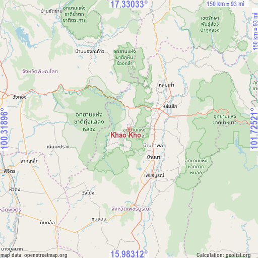
Khao Kho GPS coordinates[2]
16° 39' 28.476" North, 101° 1' 19.488" East
| Map corner | latitude | longitude |
|---|---|---|
| Upper-left | 17.33033°, | 100.31896° |
| Center: | 16.65791°, | 101.02208° |
| Lower-right: | 15.98312°, | 101.72521° |
| Map W x H: | 149.8×149.8 km | = 93.1×93.1mi |
| max Lat: | 20.43353° ⇑25.8% North |
| Khao Kho: | 16.65791° |
| min Lat: | ⇓74.2% South 5.77434° |
| min Long | Khao Kho | max Long |
| 97.93288° | 101.02208° | 105.49506° |
| W 54.6%⇐ | ⇒45.4% E |
Elevation
Elevation of Khao Kho is 926 m = 3038 ft, and this is 800.5 m = 2626 ft above average elevation for this country.
| Max E: |
1011 m = 3317 ft | 0.2% |
| Khao Kho | 926 m 3038 ft | |
| Avg. | 125.5 m = 412 ft | |
Min E: |
1 m = 3 ft | 99.8% |
See also: Thailand elevation on elevation.city.
Geographical zone
Khao Kho is located in North Torrid zone (between Equator and Tropic of Cancer). Distance of this Northern Tropic circle is 753.7 km =468.3 mi to North.| Distance of | km | miles | from Khao Kho |
|---|---|---|---|
| North Pole | 8154.9 | 5067.2 | to North |
| Arctic Circle | 5549 | 3448 | to North |
| Tropic Cancer | 753.7 | 468.3 | to North |
| Equator | 1852.2 | 1150.9 | to South |


Nearby cities:
15 places around Khao Kho: (largest is in red/bold)
• Chon Daen
54.9 km =34.1 mi,  198°
198°
• Dan Sai
70.4 km =43.7 mi,  10°
10°
• Lom Kao
33.6 km =20.9 mi,  40°
40°
• Lom Sak
27.1 km =16.8 mi,  59°
59°
• Nakhon Thai
53 km =32.9 mi,  338°
338°
• Nam Nao
70 km =43.5 mi,  79°
79°
• Noen Maprang
42.6 km =26.5 mi,  256°
256°
• Nong Phai
74.4 km =46.2 mi,  176°
176°
• Phetchabun
30.4 km =18.9 mi,  150°
150°
• Phichit
75.7 km =47 mi,  251°
251°
• Sak Lek
61.1 km =38 mi, 253°
• Thap Khlo
71.6 km =44.5 mi,  219°
219°
• Wang Pong
42.8 km =26.6 mi,  214°
214°
• Wang Sai Phun
59.7 km =37.1 mi,  239°
239°
• Wang Thong
65.8 km =40.9 mi,  286°
286°
Sources, notices
• [Note1] Compared only with cities in Thailand existing in our database
• [Src1] Map data: © OpenStreetMap contributors (CC-BY-SA)
• [Src2] Other city data from geonames.org with taken over terms of usage.
• [Src3] Geographical zone / Annual Mean Temperature by Robert A. Rohde @ Wikipedia
