Nong Phai geodata
Nong Phai (Phetchabun) is a seat of a second-order administrative division; located in Thailand in Asia/Bangkok (GMT+7) time zone. With population of 27,756 people, there are 119 cities with bigger population in this country. Compared to other cities in Thailand, 65% of cities are located further ↓South; 55% of cities are located further ←West and 51.2% of cities have lower elevation than Nong Phai. Note1


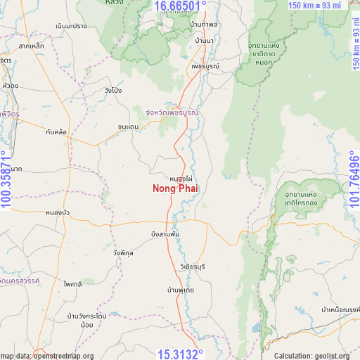
Nong Phai GPS coordinates[2]
15° 59' 24.9" North, 101° 3' 42.588" East
| Map corner | latitude | longitude |
|---|---|---|
| Upper-left | 16.66501°, | 100.35871° |
| Center: | 15.99025°, | 101.06183° |
| Lower-right: | 15.3132°, | 101.76496° |
| Map W x H: | 150.3×150.3 km | = 93.4×93.4mi |
| max Lat: | 20.43353° ⇑35% North |
| Nong Phai: | 15.99025° |
| min Lat: | ⇓65% South 5.77434° |
| min Long | Nong Phai | max Long |
| 97.93288° | 101.06183° | 105.49506° |
| W 55%⇐ | ⇒45% E |
Elevation
Elevation of Nong Phai is 111 m = 364 ft, and this is 14.5 m = 48 ft below average elevation for this country.
| Max E: |
1011 m = 3317 ft | 48.8% |
| Avg. | 125.5 m = 412 ft | |
| Nong Phai | 111 m = 364 ft | |
Min E: |
1 m = 3 ft | 51.2% |
See also: Thailand elevation on elevation.city.
Geographical zone
Nong Phai is located in North Torrid zone (between Equator and Tropic of Cancer). Distance of this Northern Tropic circle is 828 km =514.5 mi to North.| Distance of | km | miles | from Nong Phai |
|---|---|---|---|
| North Pole | 8229.1 | 5113.3 | to North |
| Arctic Circle | 5623.2 | 3494.1 | to North |
| Tropic Cancer | 828 | 514.5 | to North |
| Equator | 1777.9 | 1104.7 | to South |


Nearby cities:
15 places around Nong Phai: (largest is in red/bold)
• Bang Mun Nak
73.1 km =45.4 mi,  273°
273°
• Bueng Sam Phan
23.4 km =14.5 mi,  220°
220°
• Chon Daen
30.9 km =19.2 mi,  315°
315°
• Dong Charoen
42.8 km =26.6 mi, 274°
• Khok Charoen
72.7 km =45.2 mi,  200°
200°
• Nong Bua
52.8 km =32.8 mi,  254°
254°
• Phai Sali
61.9 km =38.5 mi,  225°
225°
• Phakdi Chumphon
39.7 km =24.7 mi,  103°
103°
• Phetchabun
48.8 km =30.3 mi,  12°
12°
• Sap Yai
71.2 km =44.2 mi,  123°
123°
• Si Thep
59.8 km =37.2 mi,  179°
179°
• Thap Khlo
53.2 km =33.1 mi,  290°
290°
• Wang Pong
48.5 km =30.1 mi, 323°
• Wang Sai Phun
71.3 km =44.3 mi,  308°
308°
• Wichian Buri
37.3 km =23.2 mi,  172°
172°
Sources, notices
• [Note1] Compared only with cities in Thailand existing in our database
• [Src1] Map data: © OpenStreetMap contributors (CC-BY-SA)
• [Src2] Other city data from geonames.org with taken over terms of usage.
• [Src3] Geographical zone / Annual Mean Temperature by Robert A. Rohde @ Wikipedia
