Chon Daen geodata
Chon Daen (Phetchabun) is a seat of a second-order administrative division; located in Thailand in Asia/Bangkok (GMT+7) time zone. With population of 17,567 people, there are 179 cities with bigger population in this country. Compared to other cities in Thailand, 68.3% of cities are located further ↓South; 51.9% of cities are located further ←West and 50.7% of cities have lower elevation than Chon Daen. Note1


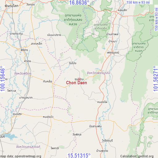
Chon Daen GPS coordinates[2]
16° 11' 22.308" North, 100° 51' 34.488" East
| Map corner | latitude | longitude |
|---|---|---|
| Upper-left | 16.8636°, | 100.15646° |
| Center: | 16.18953°, | 100.85958° |
| Lower-right: | 15.51315°, | 101.56271° |
| Map W x H: | 150.2×150.2 km | = 93.3×93.3mi |
| max Lat: | 20.43353° ⇑31.7% North |
| Chon Daen: | 16.18953° |
| min Lat: | ⇓68.3% South 5.77434° |
| min Long | Chon Daen | max Long |
| 97.93288° | 100.85958° | 105.49506° |
| W 51.9%⇐ | ⇒48.1% E |
Elevation
Elevation of Chon Daen is 106 m = 348 ft, and this is 19.5 m = 64 ft below average elevation for this country.
| Max E: |
1011 m = 3317 ft | 49.3% |
| Avg. | 125.5 m = 412 ft | |
| Chon Daen | 106 m = 348 ft | |
Min E: |
1 m = 3 ft | 50.7% |
See also: Thailand elevation on elevation.city.
Geographical zone
Chon Daen is located in North Torrid zone (between Equator and Tropic of Cancer). Distance of this Northern Tropic circle is 805.8 km =500.7 mi to North.| Distance of | km | miles | from Chon Daen |
|---|---|---|---|
| North Pole | 8207 | 5099.6 | to North |
| Arctic Circle | 5601.1 | 3480.4 | to North |
| Tropic Cancer | 805.8 | 500.7 | to North |
| Equator | 1800.1 | 1118.5 | to South |


Nearby cities:
15 places around Chon Daen: (largest is in red/bold)
• Bang Mun Nak
54.4 km =33.8 mi,  250°
250°
• Bueng Sam Phan
40.5 km =25.2 mi,  170°
170°
• Dong Charoen
28.2 km =17.5 mi,  228°
228°
• Khao Kho
54.9 km =34.1 mi,  18°
18°
• Noen Maprang
48.4 km =30.1 mi,  330°
330°
• Nong Bua
46.5 km =28.9 mi,  218°
218°
• Nong Phai
30.9 km =19.2 mi,  135°
135°
• Phetchabun
41 km =25.5 mi,  51°
51°
• Phichit
61.3 km =38.1 mi,  297°
297°
• Sak Lek
54.3 km =33.7 mi,  310°
310°
• Taphan Hin
47.1 km =29.3 mi,  274°
274°
• Thap Khlo
28.3 km =17.6 mi,  263°
263°
• Wang Pong
18.3 km =11.4 mi,  337°
337°
• Wang Sai Phun
40.8 km =25.4 mi, 302°
• Wichian Buri
64.7 km =40.2 mi,  155°
155°
Sources, notices
• [Note1] Compared only with cities in Thailand existing in our database
• [Src1] Map data: © OpenStreetMap contributors (CC-BY-SA)
• [Src2] Other city data from geonames.org with taken over terms of usage.
• [Src3] Geographical zone / Annual Mean Temperature by Robert A. Rohde @ Wikipedia
