Wichian Buri geodata
Wichian Buri (Phetchabun) is a seat of a second-order administrative division; located in Thailand in Asia/Bangkok (GMT+7) time zone. With population of 39,272 people, there are 80 cities with bigger population in this country. Compared to other cities in Thailand, 60.8% of cities are located further ↓South; 56.2% of cities are located further ←West and 52.2% of cities have higher elevation than Wichian Buri. Note1


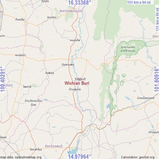
Wichian Buri GPS coordinates[2]
15° 39' 28.008" North, 101° 6' 21.708" East
| Map corner | latitude | longitude |
|---|---|---|
| Upper-left | 16.33368°, | 100.40291° |
| Center: | 15.65778°, | 101.10603° |
| Lower-right: | 14.97964°, | 101.80916° |
| Map W x H: | 150.6×150.6 km | = 93.6×93.6mi |
| max Lat: | 20.43353° ⇑39.2% North |
| Wichian Buri: | 15.65778° |
| min Lat: | ⇓60.8% South 5.77434° |
| min Long | Wichian Buri | max Long |
| 97.93288° | 101.10603° | 105.49506° |
| W 56.2%⇐ | ⇒43.8% E |
Elevation
Elevation of Wichian Buri is 72 m = 236 ft, and this is 53.5 m = 176 ft below average elevation for this country.
| Max E: |
1011 m = 3317 ft | 52.2% |
| Avg. | 125.5 m = 412 ft | |
| Wichian Buri | 72 m = 236 ft | |
Min E: |
1 m = 3 ft | 47.8% |
See also: Thailand elevation on elevation.city.
Geographical zone
Wichian Buri is located in North Torrid zone (between Equator and Tropic of Cancer). Distance of this Northern Tropic circle is 864.9 km =537.4 mi to North.| Distance of | km | miles | from Wichian Buri |
|---|---|---|---|
| North Pole | 8266.1 | 5136.3 | to North |
| Arctic Circle | 5660.2 | 3517.1 | to North |
| Tropic Cancer | 864.9 | 537.4 | to North |
| Equator | 1741 | 1081.8 | to South |


Nearby cities:
15 places around Wichian Buri: (largest is in red/bold)
• Bueng Sam Phan
27.7 km =17.2 mi,  313°
313°
• Chai Badan
51 km =31.7 mi,  176°
176°
• Chon Daen
64.7 km =40.2 mi,  335°
335°
• Dong Charoen
62.2 km =38.6 mi, 310°
• Khok Charoen
43.7 km =27.2 mi,  224°
224°
• Lam Sonthi
48.3 km =30 mi,  145°
145°
• Nong Bua
60.2 km =37.4 mi,  292°
292°
• Nong Phai
37.3 km =23.2 mi,  352°
352°
• Phai Sali
49.3 km =30.6 mi,  262°
262°
• Phakdi Chumphon
43.6 km =27.1 mi,  50°
50°
• Sa Bot
57.9 km =36 mi,  210°
210°
• Sap Yai
54.7 km =34 mi,  92°
92°
• Si Thep
23.3 km =14.5 mi,  190°
190°
• Thep Sathit
47.3 km =29.4 mi,  128°
128°
• Thepharak
61.4 km =38.2 mi, 129°
Sources, notices
• [Note1] Compared only with cities in Thailand existing in our database
• [Src1] Map data: © OpenStreetMap contributors (CC-BY-SA)
• [Src2] Other city data from geonames.org with taken over terms of usage.
• [Src3] Geographical zone / Annual Mean Temperature by Robert A. Rohde @ Wikipedia
