Chon Buri geodata
Chon Buri is a seat of a first-order administrative division; located in Thailand in Asia/Bangkok (GMT+7) time zone. With population of 219,164 people, there are 4 cities with bigger population in this country. Compared to other cities in Thailand, 76.4% of cities are located further ↑North; 53.7% of cities are located further ←West and 91.2% of cities have higher elevation than Chon Buri. Note1


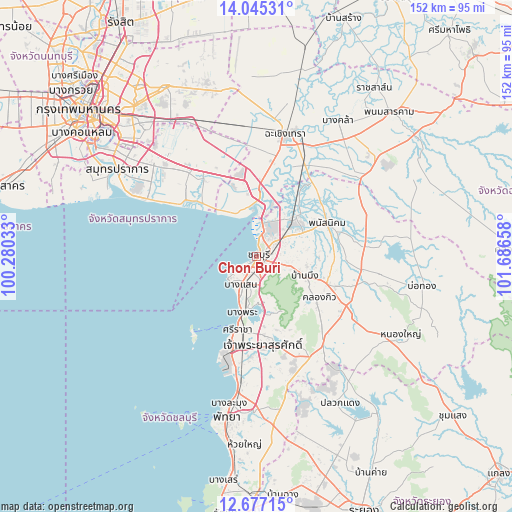
Chon Buri GPS coordinates[2]
13° 21' 43.92" North, 100° 59' 0.42" East
| Map corner | latitude | longitude |
|---|---|---|
| Upper-left | 14.04531°, | 100.28033° |
| Center: | 13.3622°, | 100.98345° |
| Lower-right: | 12.67715°, | 101.68658° |
| Map W x H: | 152.1×152.1 km | = 94.5×94.5mi |
| max Lat: | 20.43353° ⇑76.4% North |
| Chon Buri: | 13.3622° |
| min Lat: | ⇓23.6% South 5.77434° |
| min Long | Chon Buri | max Long |
| 97.93288° | 100.98345° | 105.49506° |
| W 53.7%⇐ | ⇒46.3% E |
Elevation
Elevation of Chon Buri is 8 m = 26 ft, and this is 117.5 m = 385 ft below average elevation for this country.
| Max E: |
1011 m = 3317 ft | 91.2% |
| Avg. | 125.5 m = 412 ft | |
| Chon Buri | 8 m = 26 ft | |
Min E: |
1 m = 3 ft | 8.8% |
See also: Chon Buri elevation on elevation.city.
Geographical zone
Chon Buri is located in North Torrid zone (between Equator and Tropic of Cancer). Distance of this Northern Tropic circle is 1120.2 km =696.1 mi to North.| Distance of | km | miles | from Chon Buri |
|---|---|---|---|
| North Pole | 8521.3 | 5294.9 | to North |
| Arctic Circle | 5915.4 | 3675.7 | to North |
| Tropic Cancer | 1120.2 | 696.1 | to North |
| Equator | 1485.7 | 923.2 | to South |


Nearby cities:
15 places around Chon Buri: (largest is in red/bold)
• Ban Bueng
15 km =9.3 mi,  112°
112°
• Ban Khlong Bang Sao Thong
35.1 km =21.8 mi,  332°
332°
• Ban Pho
28.3 km =17.6 mi,  21°
21°
• Ban Talat Bueng
32.4 km =20.1 mi,  176°
176°
• Bang Bo
28.5 km =17.7 mi, 325°
• Bang Bo District
30.5 km =19 mi,  323°
323°
• Bang Lamung
35.5 km =22.1 mi,  189°
189°
• Bang Pakong
20.1 km =12.5 mi,  3°
3°
• Bang Sao Thong
30.7 km =19.1 mi, 327°
• Chachoengsao
37.5 km =23.3 mi,  14°
14°
• Ko Chan
38.5 km =23.9 mi,  80°
80°
• Ko Si Chang
29.3 km =18.2 mi,  221°
221°
• Phan Thong
16.9 km =10.5 mi,  45°
45°
• Phanat Nikhom
23.6 km =14.7 mi,  66°
66°
• Si Racha
21.7 km =13.5 mi,  195°
195°
Sources, notices
• [Note1] Compared only with cities in Thailand existing in our database
• [Src1] Map data: © OpenStreetMap contributors (CC-BY-SA)
• [Src2] Other city data from geonames.org with taken over terms of usage.
• [Src3] Geographical zone / Annual Mean Temperature by Robert A. Rohde @ Wikipedia
