Bang Bo District geodata
Bang Bo District (Samut Prakan) is a populated place; located in Thailand in Asia/Bangkok (GMT+7) time zone. With population of 28,376 people, there are 114 cities with bigger population in this country. Compared to other cities in Thailand, 74.4% of cities are located further ↑North; 51% of cities are located further ←West and 99.3% of cities have higher elevation than Bang Bo District. Note1


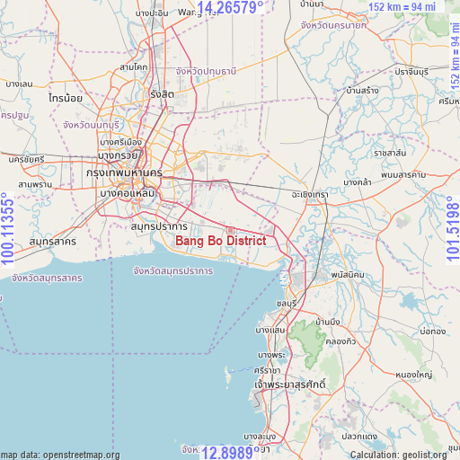
Bang Bo District GPS coordinates[2]
13° 34' 59.988" North, 100° 49' 0.012" East
| Map corner | latitude | longitude |
|---|---|---|
| Upper-left | 14.26579°, | 100.11355° |
| Center: | 13.58333°, | 100.81667° |
| Lower-right: | 12.8989°, | 101.5198° |
| Map W x H: | 152×152 km | = 94.4×94.4mi |
| max Lat: | 20.43353° ⇑74.4% North |
| Bang Bo District: | 13.58333° |
| min Lat: | ⇓25.6% South 5.77434° |
| min Long | Bang Bo Distric | max Long |
| 97.93288° | 100.81667° | 105.49506° |
| W 51%⇐ | ⇒49% E |
Elevation
Elevation of Bang Bo District is 4 m = 13 ft, and this is 121.5 m = 399 ft below average elevation for this country.
| Max E: |
1011 m = 3317 ft | 99.3% |
| Avg. | 125.5 m = 412 ft | |
| Bang Bo District | 4 m = 13 ft | |
Min E: |
1 m = 3 ft | 0.7% |
See also: Thailand elevation on elevation.city.
Geographical zone
Bang Bo District is located in North Torrid zone (between Equator and Tropic of Cancer). Distance of this Northern Tropic circle is 1095.6 km =680.8 mi to North.| Distance of | km | miles | from Bang Bo District |
|---|---|---|---|
| North Pole | 8496.7 | 5279.6 | to North |
| Arctic Circle | 5890.8 | 3660.4 | to North |
| Tropic Cancer | 1095.6 | 680.8 | to North |
| Equator | 1510.3 | 938.5 | to South |


Nearby cities:
15 places around Bang Bo District: (largest is in red/bold)
• Ban Khlong Bang Sao Thong
6.7 km =4.2 mi,  14°
14°
• Ban Pho
28.5 km =17.7 mi,  86°
86°
• Bang Bo
2.3 km =1.4 mi,  116°
116°
• Bang Kapi
27.3 km =17 mi,  317°
317°
• Bang Na
21.1 km =13.1 mi,  296°
296°
• Bang Pakong
19.6 km =12.2 mi,  103°
103°
• Bang Sao Thong
2 km =1.2 mi,  48°
48°
• Bueng Kum
27.5 km =17.1 mi, 324°
• Lat Krabang
16 km =9.9 mi,  347°
347°
• Min Buri
27.3 km =17 mi,  340°
340°
• Phra Khanong
26.7 km =16.6 mi, 299°
• Phra Samut Chedi
26.5 km =16.5 mi,  274°
274°
• Samut Prakan
23.8 km =14.8 mi, 274°
• Saphan Sung
25.2 km =15.7 mi,  325°
325°
• Suan Luang
24.2 km =15 mi,  312°
312°
Sources, notices
• [Note1] Compared only with cities in Thailand existing in our database
• [Src1] Map data: © OpenStreetMap contributors (CC-BY-SA)
• [Src2] Other city data from geonames.org with taken over terms of usage.
• [Src3] Geographical zone / Annual Mean Temperature by Robert A. Rohde @ Wikipedia
