Bang Pakong geodata
Bang Pakong (Chachoengsao) is a seat of a second-order administrative division; located in Thailand in Asia/Bangkok (GMT+7) time zone. With population of 25,620 people, there are 126 cities with bigger population in this country. Compared to other cities in Thailand, 74.7% of cities are located further ↑North; 54% of cities are located further ←West and 91.2% of cities have higher elevation than Bang Pakong. Note1


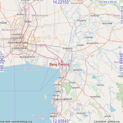
Bang Pakong GPS coordinates[2]
13° 32' 34.692" North, 100° 59' 35.988" East
| Map corner | latitude | longitude |
|---|---|---|
| Upper-left | 14.22555°, | 100.29021° |
| Center: | 13.54297°, | 100.99333° |
| Lower-right: | 12.85843°, | 101.69646° |
| Map W x H: | 152×152 km | = 94.4×94.4mi |
| max Lat: | 20.43353° ⇑74.7% North |
| Bang Pakong: | 13.54297° |
| min Lat: | ⇓25.3% South 5.77434° |
| min Long | Bang Pakong | max Long |
| 97.93288° | 100.99333° | 105.49506° |
| W 54%⇐ | ⇒46% E |
Elevation
Elevation of Bang Pakong is 8 m = 26 ft, and this is 117.5 m = 385 ft below average elevation for this country.
| Max E: |
1011 m = 3317 ft | 91.2% |
| Avg. | 125.5 m = 412 ft | |
| Bang Pakong | 8 m = 26 ft | |
Min E: |
1 m = 3 ft | 8.8% |
See also: Thailand elevation on elevation.city.
Geographical zone
Bang Pakong is located in North Torrid zone (between Equator and Tropic of Cancer). Distance of this Northern Tropic circle is 1100.1 km =683.6 mi to North.| Distance of | km | miles | from Bang Pakong |
|---|---|---|---|
| North Pole | 8501.2 | 5282.4 | to North |
| Arctic Circle | 5895.3 | 3663.2 | to North |
| Tropic Cancer | 1100.1 | 683.6 | to North |
| Equator | 1505.8 | 935.7 | to South |


Nearby cities:
15 places around Bang Pakong: (largest is in red/bold)
• Ban Bueng
28.8 km =17.9 mi,  153°
153°
• Ban Khlong Bang Sao Thong
20.5 km =12.7 mi,  302°
302°
• Ban Pho
11.2 km =7 mi,  56°
56°
• Bang Bo
17.4 km =10.8 mi,  281°
281°
• Bang Bo District
19.6 km =12.2 mi, 283°
• Bang Khla
30.5 km =19 mi,  49°
49°
• Bang Nam Priao
34.5 km =21.4 mi,  10°
10°
• Bang Sao Thong
18.5 km =11.5 mi,  288°
288°
• Chachoengsao
18.2 km =11.3 mi,  27°
27°
• Chon Buri
20.1 km =12.5 mi,  183°
183°
• Khlong Khuean
33.2 km =20.6 mi, 33°
• Lat Krabang
30.2 km =18.8 mi,  311°
311°
• Phan Thong
13.8 km =8.6 mi,  127°
127°
• Phanat Nikhom
23.3 km =14.5 mi,  117°
117°
• Plaeng Yao
31.8 km =19.8 mi,  81°
81°
Sources, notices
• [Note1] Compared only with cities in Thailand existing in our database
• [Src1] Map data: © OpenStreetMap contributors (CC-BY-SA)
• [Src2] Other city data from geonames.org with taken over terms of usage.
• [Src3] Geographical zone / Annual Mean Temperature by Robert A. Rohde @ Wikipedia
