Thep Sathit geodata
Thep Sathit (Chaiyaphum) is a seat of a second-order administrative division; located in Thailand in Asia/Bangkok (GMT+7) time zone. In our database, there are 331 cities with bigger population. Compared to other cities in Thailand, 57% of cities are located further ↓South; 61.1% of cities are located further ←West and 92.5% of cities have lower elevation than Thep Sathit. Note1


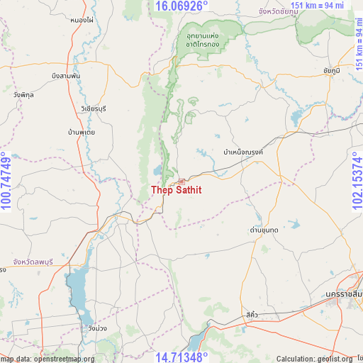
Thep Sathit GPS coordinates[2]
15° 23' 32.892" North, 101° 27' 2.196" East
| Map corner | latitude | longitude |
|---|---|---|
| Upper-left | 16.06926°, | 100.74749° |
| Center: | 15.39247°, | 101.45061° |
| Lower-right: | 14.71348°, | 102.15374° |
| Map W x H: | 150.7×150.8 km | = 93.6×93.7mi |
| max Lat: | 20.43353° ⇑43% North |
| Thep Sathit: | 15.39247° |
| min Lat: | ⇓57% South 5.77434° |
| min Long | Thep Sathit | max Long |
| 97.93288° | 101.45061° | 105.49506° |
| W 61.1%⇐ | ⇒38.9% E |
Elevation
Elevation of Thep Sathit is 317 m = 1040 ft, and this is 191.5 m = 628 ft above average elevation for this country.
| Max E: |
1011 m = 3317 ft | 7.5% |
| Thep Sathit | 317 m 1040 ft | |
| Avg. | 125.5 m = 412 ft | |
Min E: |
1 m = 3 ft | 92.5% |
See also: Thailand elevation on elevation.city.
Geographical zone
Thep Sathit is located in North Torrid zone (between Equator and Tropic of Cancer). Distance of this Northern Tropic circle is 894.4 km =555.8 mi to North.| Distance of | km | miles | from Thep Sathit |
|---|---|---|---|
| North Pole | 8295.6 | 5154.6 | to North |
| Arctic Circle | 5689.7 | 3535.4 | to North |
| Tropic Cancer | 894.4 | 555.8 | to North |
| Equator | 1711.5 | 1063.5 | to South |


Nearby cities:
15 places around Thep Sathit: (largest is in red/bold)
• Amphoe Sikhiu
61.4 km =38.2 mi,  153°
153°
• Bamnet Narong
28.4 km =17.6 mi,  64°
64°
• Chai Badan
40.2 km =25 mi,  237°
237°
• Chatturat
46.5 km =28.9 mi,  65°
65°
• Dan Khun Thot
40 km =24.9 mi,  120°
120°
• Lam Sonthi
13.8 km =8.6 mi,  222°
222°
• Noen Sa-nga
62 km =38.5 mi, 72°
• Nong Bua Rawe
52.3 km =32.5 mi,  39°
39°
• Phakdi Chumphon
57.1 km =35.5 mi,  356°
356°
• Phra Thong Kham
62.7 km =39 mi,  102°
102°
• Sap Yai
32.5 km =20.2 mi,  33°
33°
• Si Thep
41.7 km =25.9 mi,  279°
279°
• Tha Luang
52 km =32.3 mi,  226°
226°
• Thepharak
14.2 km =8.8 mi,  131°
131°
• Wichian Buri
47.3 km =29.4 mi,  308°
308°
Sources, notices
• [Note1] Compared only with cities in Thailand existing in our database
• [Src1] Map data: © OpenStreetMap contributors (CC-BY-SA)
• [Src2] Other city data from geonames.org with taken over terms of usage.
• [Src3] Geographical zone / Annual Mean Temperature by Robert A. Rohde @ Wikipedia
