Lospalos geodata
Lospalos (Lautém) is a seat of a first-order administrative division; located in Timor Leste in Asia/Dili (GMT+9) time zone. With population of 17,186 people, there are 5 cities with bigger population in this country. Compared to other cities in Timor Leste, 86.7% of cities are located further ↓South; 100% of cities are located further ←West and 60% of cities have lower elevation than Lospalos. Note1


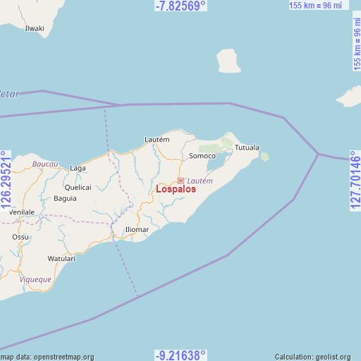
Lospalos GPS coordinates[2]
8° 31' 18.012" South, 126° 59' 53.988" East
| Map corner | latitude | longitude |
|---|---|---|
| Upper-left | -7.82569°, | 126.29521° |
| Center: | -8.52167°, | 126.99833° |
| Lower-right: | -9.21638°, | 127.70146° |
| Map W x H: | 154.6×154.6 km | = 96.1×96.1mi |
| max Lat: | -8.47572° ⇑13.3% North |
| Lospalos: | -8.52167° |
| min Lat: | ⇓86.7% South -9.31286° |
| min Long | Lospalos | max Long |
| 124.38333° | 126.99833° | 126.99833° |
| W 100%⇐ | ⇒0% E |
Elevation
Elevation of Lospalos is 341 m = 1119 ft, and this is 34.9 m = 115 ft above average elevation for this country.
| Max E: |
926 m = 3038 ft | 40% |
| Lospalos | 341 m 1119 ft | |
| Avg. | 306.1 m = 1004 ft | |
Min E: |
3 m = 10 ft | 60% |
See also: Timor Leste elevation on elevation.city.
Geographical zone
Lospalos is located in South Torrid zone (between Equator and Tropic of Capricorn). Distance of Equator is 947.5 km =588.7 mi to North.| Distance of | km | miles | from Lospalos |
|---|---|---|---|
| Equator | 947.5 | 588.7 | to North |
| Tropic Capricorn | 1658.4 | 1030.5 | to South |
| Antarctic Circle | 6453.7 | 4010.1 | to South |
| South Pole | 9059.5 | 5629.3 | to South |


Nearby cities:
15 places around Lospalos: (largest is in red/bold)
• Aileu
159.1 km =98.9 mi,  261°
261°
• Ainaro
171.9 km =106.8 mi,  252°
252°
• Baukau
59.8 km =37.2 mi,  274°
274°
• Dili
156.7 km =97.4 mi, 268°
• Gleno
173.2 km =107.6 mi, 262°
• Likisá
182.3 km =113.3 mi, 267°
• Maliana
202.3 km =125.7 mi, 255°
• Manatutu
108.3 km =67.3 mi, 270°
• Maubara
197.3 km =122.6 mi, 267°
• Metinaro
138.2 km =85.9 mi, 269°
• Pante Makasar
297 km =184.5 mi, 255°
• Same
157.7 km =98 mi, 250°
• Suai
210.6 km =130.9 mi, 245°
• Venilale
69.5 km =43.2 mi, 258°
• Viqueque
79 km =49.1 mi,  241°
241°
Sources, notices
• [Note1] Compared only with cities in Timor Leste existing in our database
• [Src1] Map data: © OpenStreetMap contributors (CC-BY-SA)
• [Src2] Other city data from geonames.org with taken over terms of usage.
• [Src3] Geographical zone / Annual Mean Temperature by Robert A. Rohde @ Wikipedia
