Pante Makasar geodata
Pante Makasar (Oecusse) is a seat of a first-order administrative division; located in Timor Leste in Asia/Dili (GMT+9) time zone. With population of 4,730 people, there are 13 cities with bigger population in this country. Compared to other cities in Timor Leste, 93.3% of cities are located further ↑North; 100% of cities are located further →East and 66.7% of cities have higher elevation than Pante Makasar. Note1


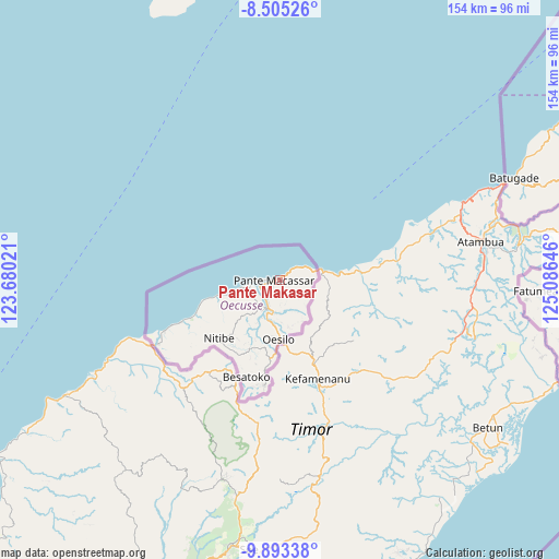
Pante Makasar GPS coordinates[2]
9° 12' 0" South, 124° 22' 59.988" East
| Map corner | latitude | longitude |
|---|---|---|
| Upper-left | -8.50526°, | 123.68021° |
| Center: | -9.2°, | 124.38333° |
| Lower-right: | -9.89338°, | 125.08646° |
| Map W x H: | 154.3×154.3 km | = 95.9×95.9mi |
| max Lat: | -8.47572° ⇑93.3% North |
| Pante Makasar: | -9.2° |
| min Lat: | ⇓6.7% South -9.31286° |
| min Long | Pante Makasar | max Long |
| 124.38333° | 124.38333° | 126.99833° |
| W 0%⇐ | ⇒100% E |
Elevation
Elevation of Pante Makasar is 24 m = 79 ft, and this is 282.1 m = 926 ft below average elevation for this country.
| Max E: |
926 m = 3038 ft | 66.7% |
| Avg. | 306.1 m = 1004 ft | |
| Pante Makasar | 24 m = 79 ft | |
Min E: |
3 m = 10 ft | 33.3% |
See also: Timor Leste elevation on elevation.city.
Geographical zone
Pante Makasar is located in South Torrid zone (between Equator and Tropic of Capricorn). Distance of Equator is 1022.9 km =635.6 mi to North.| Distance of | km | miles | from Pante Makasar |
|---|---|---|---|
| Equator | 1022.9 | 635.6 | to North |
| Tropic Capricorn | 1583 | 983.6 | to South |
| Antarctic Circle | 6378.2 | 3963.2 | to South |
| South Pole | 8984.1 | 5582.5 | to South |


Nearby cities:
15 places around Pante Makasar: (largest is in red/bold)
• Aileu
140.1 km =87.1 mi,  68°
68°
• Ainaro
125.6 km =78 mi,  79°
79°
• Baukau
241.6 km =150.1 mi, 70°
• Dili
148.9 km =92.5 mi,  61°
61°
• Gleno
127.2 km =79 mi, 65°
• Likisá
125.4 km =77.9 mi, 57°
• Lospalos
297 km =184.5 mi, 75°
• Maliana
94.7 km =58.8 mi, 75°
• Manatutu
194.7 km =121 mi, 66°
• Maubara
111.6 km =69.3 mi,  54°
54°
• Metinaro
166.8 km =103.6 mi, 63°
• Same
140.6 km =87.4 mi, 81°
• Suai
96.6 km =60 mi,  97°
97°
• Venilale
227.7 km =141.5 mi, 74°
• Viqueque
220.9 km =137.3 mi, 80°
Sources, notices
• [Note1] Compared only with cities in Timor Leste existing in our database
• [Src1] Map data: © OpenStreetMap contributors (CC-BY-SA)
• [Src2] Other city data from geonames.org with taken over terms of usage.
• [Src3] Geographical zone / Annual Mean Temperature by Robert A. Rohde @ Wikipedia
