Maubara geodata
Maubara (Liquiçá) is a populated place; located in Timor Leste in Asia/Dili (GMT+9) time zone. With population of 16,300 people, there are 6 cities with bigger population in this country. Compared to other cities in Timor Leste, 60% of cities are located further ↓South; 93.3% of cities are located further →East and 80% of cities have higher elevation than Maubara. Note1


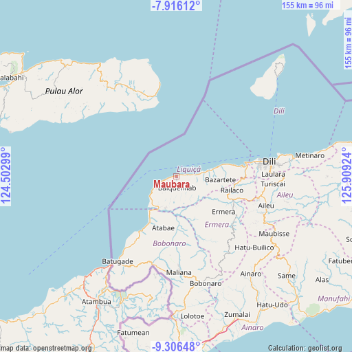
Maubara GPS coordinates[2]
8° 36' 42.984" South, 125° 12' 21.996" East
| Map corner | latitude | longitude |
|---|---|---|
| Upper-left | -7.91612°, | 124.50299° |
| Center: | -8.61194°, | 125.20611° |
| Lower-right: | -9.30648°, | 125.90924° |
| Map W x H: | 154.6×154.6 km | = 96.1×96.1mi |
| max Lat: | -8.47572° ⇑40% North |
| Maubara: | -8.61194° |
| min Lat: | ⇓60% South -9.31286° |
| min Long | Maubara | max Long |
| 124.38333° | 125.20611° | 126.99833° |
| W 6.7%⇐ | ⇒93.3% E |
Elevation
Elevation of Maubara is 21 m = 69 ft, and this is 285.1 m = 935 ft below average elevation for this country.
| Max E: |
926 m = 3038 ft | 80% |
| Avg. | 306.1 m = 1004 ft | |
| Maubara | 21 m = 69 ft | |
Min E: |
3 m = 10 ft | 20% |
See also: Timor Leste elevation on elevation.city.
Geographical zone
Maubara is located in South Torrid zone (between Equator and Tropic of Capricorn). Distance of Equator is 957.6 km =595 mi to North.| Distance of | km | miles | from Maubara |
|---|---|---|---|
| Equator | 957.6 | 595 | to North |
| Tropic Capricorn | 1648.4 | 1024.3 | to South |
| Antarctic Circle | 6443.6 | 4003.9 | to South |
| South Pole | 9049.5 | 5623.1 | to South |


Nearby cities:
15 places around Maubara: (largest is in red/bold)
• Aileu
41.7 km =25.9 mi,  108°
108°
• Ainaro
53.8 km =33.4 mi,  141°
141°
• Baukau
138.3 km =85.9 mi,  83°
83°
• Dili
40.8 km =25.4 mi, 81°
• Gleno
28.2 km =17.5 mi,  116°
116°
• Likisá
15.2 km =9.4 mi, 79°
• Lospalos
197.3 km =122.6 mi,  87°
87°
• Maliana
42.2 km =26.2 mi,  177°
177°
• Manatutu
89.4 km =55.6 mi, 82°
• Metinaro
59.6 km =37 mi, 81°
• Pante Makasar
111.6 km =69.3 mi,  234°
234°
• Same
65.3 km =40.6 mi,  131°
131°
• Suai
78.1 km =48.5 mi, 175°
• Venilale
128.9 km =80.1 mi, 91°
• Viqueque
130.2 km =80.9 mi,  102°
102°
Sources, notices
• [Note1] Compared only with cities in Timor Leste existing in our database
• [Src1] Map data: © OpenStreetMap contributors (CC-BY-SA)
• [Src2] Other city data from geonames.org with taken over terms of usage.
• [Src3] Geographical zone / Annual Mean Temperature by Robert A. Rohde @ Wikipedia
