Metinaro geodata
Metinaro (Díli) is a populated place; located in Timor Leste in Asia/Dili (GMT+9) time zone. With population of 4,000 people, there are 14 cities with bigger population in this country. Compared to other cities in Timor Leste, 80% of cities are located further ↓South; 66.7% of cities are located further ←West and 86.7% of cities have higher elevation than Metinaro. Note1


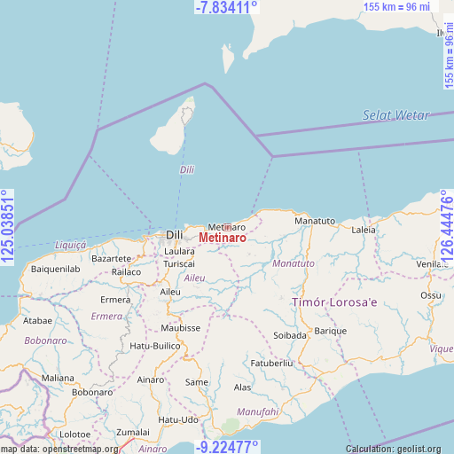
Metinaro GPS coordinates[2]
8° 31' 48.252" South, 125° 44' 29.868" East
| Map corner | latitude | longitude |
|---|---|---|
| Upper-left | -7.83411°, | 125.03851° |
| Center: | -8.53007°, | 125.74163° |
| Lower-right: | -9.22477°, | 126.44476° |
| Map W x H: | 154.6×154.6 km | = 96.1×96.1mi |
| max Lat: | -8.47572° ⇑20% North |
| Metinaro: | -8.53007° |
| min Lat: | ⇓80% South -9.31286° |
| min Long | Metinaro | max Long |
| 124.38333° | 125.74163° | 126.99833° |
| W 66.7%⇐ | ⇒33.3% E |
Elevation
Elevation of Metinaro is 15 m = 49 ft, and this is 291.1 m = 955 ft below average elevation for this country.
| Max E: |
926 m = 3038 ft | 86.7% |
| Avg. | 306.1 m = 1004 ft | |
| Metinaro | 15 m = 49 ft | |
Min E: |
3 m = 10 ft | 13.3% |
See also: Timor Leste elevation on elevation.city.
Geographical zone
Metinaro is located in South Torrid zone (between Equator and Tropic of Capricorn). Distance of Equator is 948.5 km =589.4 mi to North.| Distance of | km | miles | from Metinaro |
|---|---|---|---|
| Equator | 948.5 | 589.4 | to North |
| Tropic Capricorn | 1657.5 | 1029.9 | to South |
| Antarctic Circle | 6452.7 | 4009.5 | to South |
| South Pole | 9058.6 | 5628.8 | to South |


Nearby cities:
15 places around Metinaro: (largest is in red/bold)
• Aileu
29.3 km =18.2 mi,  221°
221°
• Ainaro
57.5 km =35.7 mi,  206°
206°
• Baukau
78.8 km =49 mi,  85°
85°
• Dili
18.7 km =11.6 mi,  260°
260°
• Gleno
39.9 km =24.8 mi,  237°
237°
• Likisá
44.4 km =27.6 mi, 261°
• Lospalos
138.2 km =85.9 mi, 89°
• Maliana
77 km =47.8 mi,  228°
228°
• Manatutu
29.9 km =18.6 mi, 86°
• Maubara
59.6 km =37 mi, 261°
• Pante Makasar
166.8 km =103.6 mi, 243°
• Same
53.7 km =33.4 mi,  190°
190°
• Suai
102.1 km =63.4 mi, 211°
• Venilale
71.1 km =44.2 mi,  100°
100°
• Viqueque
77.6 km =48.2 mi,  117°
117°
Sources, notices
• [Note1] Compared only with cities in Timor Leste existing in our database
• [Src1] Map data: © OpenStreetMap contributors (CC-BY-SA)
• [Src2] Other city data from geonames.org with taken over terms of usage.
• [Src3] Geographical zone / Annual Mean Temperature by Robert A. Rohde @ Wikipedia
