Gleno geodata
Gleno (Ermera) is a populated place; located in Timor Leste in Asia/Dili (GMT+9) time zone. With population of 8,133 people, there are 10 cities with bigger population in this country. Compared to other cities in Timor Leste, 53.3% of cities are located further ↑North; 66.7% of cities are located further →East and 80% of cities have lower elevation than Gleno. Note1


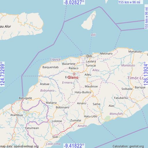
Gleno GPS coordinates[2]
8° 43' 26.004" South, 125° 26' 9.996" East
| Map corner | latitude | longitude |
|---|---|---|
| Upper-left | -8.02827°, | 124.73299° |
| Center: | -8.72389°, | 125.43611° |
| Lower-right: | -9.41822°, | 126.13924° |
| Map W x H: | 154.5×154.6 km | = 96×96.1mi |
| max Lat: | -8.47572° ⇑53.3% North |
| Gleno: | -8.72389° |
| min Lat: | ⇓46.7% South -9.31286° |
| min Long | Gleno | max Long |
| 124.38333° | 125.43611° | 126.99833° |
| W 33.3%⇐ | ⇒66.7% E |
Elevation
Elevation of Gleno is 709 m = 2326 ft, and this is 402.9 m = 1322 ft above average elevation for this country.
| Max E: |
926 m = 3038 ft | 20% |
| Gleno | 709 m 2326 ft | |
| Avg. | 306.1 m = 1004 ft | |
Min E: |
3 m = 10 ft | 80% |
See also: Timor Leste elevation on elevation.city.
Geographical zone
Gleno is located in South Torrid zone (between Equator and Tropic of Capricorn). Distance of Equator is 970 km =602.7 mi to North.| Distance of | km | miles | from Gleno |
|---|---|---|---|
| Equator | 970 | 602.7 | to North |
| Tropic Capricorn | 1635.9 | 1016.5 | to South |
| Antarctic Circle | 6431.2 | 3996.2 | to South |
| South Pole | 9037.1 | 5615.4 | to South |


Nearby cities:
15 places around Gleno: (largest is in red/bold)
• Aileu
14.3 km =8.9 mi,  91°
91°
• Ainaro
30.9 km =19.2 mi,  165°
165°
• Baukau
115.5 km =71.8 mi,  76°
76°
• Dili
23.8 km =14.8 mi,  39°
39°
• Likisá
18.4 km =11.4 mi,  325°
325°
• Lospalos
173.2 km =107.6 mi, 82°
• Maliana
38.1 km =23.7 mi,  218°
218°
• Manatutu
67.7 km =42.1 mi,  69°
69°
• Maubara
28.2 km =17.5 mi,  296°
296°
• Metinaro
39.9 km =24.8 mi,  57°
57°
• Pante Makasar
127.2 km =79 mi,  245°
245°
• Same
38.9 km =24.2 mi,  143°
143°
• Suai
68.4 km =42.5 mi,  196°
196°
• Venilale
104 km =64.6 mi, 85°
• Viqueque
103.1 km =64.1 mi,  98°
98°
Sources, notices
• [Note1] Compared only with cities in Timor Leste existing in our database
• [Src1] Map data: © OpenStreetMap contributors (CC-BY-SA)
• [Src2] Other city data from geonames.org with taken over terms of usage.
• [Src3] Geographical zone / Annual Mean Temperature by Robert A. Rohde @ Wikipedia
