Manatutu geodata
Manatutu (Manatuto) is a seat of a first-order administrative division; located in Timor Leste in Asia/Dili (GMT+9) time zone. With population of 1,924 people, there are 15 cities with bigger population in this country. Compared to other cities in Timor Leste, 93.3% of cities are located further ↓South; 73.3% of cities are located further ←West and 93.3% of cities have higher elevation than Manatutu. Note1


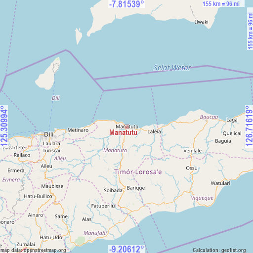
Manatutu GPS coordinates[2]
8° 30' 41.004" South, 126° 0' 47.016" East
| Map corner | latitude | longitude |
|---|---|---|
| Upper-left | -7.81539°, | 125.30994° |
| Center: | -8.51139°, | 126.01306° |
| Lower-right: | -9.20612°, | 126.71619° |
| Map W x H: | 154.6×154.6 km | = 96.1×96.1mi |
| max Lat: | -8.47572° ⇑6.7% North |
| Manatutu: | -8.51139° |
| min Lat: | ⇓93.3% South -9.31286° |
| min Long | Manatutu | max Long |
| 124.38333° | 126.01306° | 126.99833° |
| W 73.3%⇐ | ⇒26.7% E |
Elevation
Elevation of Manatutu is 8 m = 26 ft, and this is 298.1 m = 978 ft below average elevation for this country.
| Max E: |
926 m = 3038 ft | 93.3% |
| Avg. | 306.1 m = 1004 ft | |
| Manatutu | 8 m = 26 ft | |
Min E: |
3 m = 10 ft | 6.7% |
See also: Timor Leste elevation on elevation.city.
Geographical zone
Manatutu is located in South Torrid zone (between Equator and Tropic of Capricorn). Distance of Equator is 946.4 km =588.1 mi to North.| Distance of | km | miles | from Manatutu |
|---|---|---|---|
| Equator | 946.4 | 588.1 | to North |
| Tropic Capricorn | 1659.5 | 1031.2 | to South |
| Antarctic Circle | 6454.8 | 4010.8 | to South |
| South Pole | 9060.7 | 5630.1 | to South |


Nearby cities:
15 places around Manatutu: (largest is in red/bold)
• Aileu
54.7 km =34 mi,  243°
243°
• Ainaro
77.1 km =47.9 mi,  226°
226°
• Baukau
48.9 km =30.4 mi,  85°
85°
• Dili
48.6 km =30.2 mi,  263°
263°
• Gleno
67.7 km =42.1 mi,  249°
249°
• Likisá
74.3 km =46.2 mi, 263°
• Lospalos
108.3 km =67.3 mi, 90°
• Maliana
102.2 km =63.5 mi, 238°
• Maubara
89.4 km =55.6 mi, 262°
• Metinaro
29.9 km =18.6 mi,  266°
266°
• Pante Makasar
194.7 km =121 mi, 246°
• Same
67.9 km =42.2 mi,  216°
216°
• Suai
121.9 km =75.7 mi, 223°
• Venilale
42.7 km =26.5 mi,  110°
110°
• Viqueque
54.5 km =33.9 mi,  134°
134°
Sources, notices
• [Note1] Compared only with cities in Timor Leste existing in our database
• [Src1] Map data: © OpenStreetMap contributors (CC-BY-SA)
• [Src2] Other city data from geonames.org with taken over terms of usage.
• [Src3] Geographical zone / Annual Mean Temperature by Robert A. Rohde @ Wikipedia
