Suai geodata
Suai (Cova Lima) is a seat of a first-order administrative division; located in Timor Leste in Asia/Dili (GMT+9) time zone. With population of 21,539 people, there are 2 cities with bigger population in this country. Compared to other cities in Timor Leste, 100% of cities are located further ↑North; 80% of cities are located further →East and 53.3% of cities have higher elevation than Suai. Note1


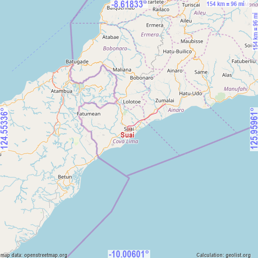
Suai GPS coordinates[2]
9° 18' 46.296" South, 125° 15' 23.328" East
| Map corner | latitude | longitude |
|---|---|---|
| Upper-left | -8.61833°, | 124.55336° |
| Center: | -9.31286°, | 125.25648° |
| Lower-right: | -10.00601°, | 125.95961° |
| Map W x H: | 154.3×154.3 km | = 95.9×95.9mi |
| max Lat: | -8.47572° ⇑100% North |
| Suai: | -9.31286° |
| min Lat: | ⇓0% South -9.31286° |
| min Long | Suai | max Long |
| 124.38333° | 125.25648° | 126.99833° |
| W 20%⇐ | ⇒80% E |
Elevation
Elevation of Suai is 73 m = 240 ft, and this is 233.1 m = 765 ft below average elevation for this country.
| Max E: |
926 m = 3038 ft | 53.3% |
| Avg. | 306.1 m = 1004 ft | |
| Suai | 73 m = 240 ft | |
Min E: |
3 m = 10 ft | 46.7% |
See also: Timor Leste elevation on elevation.city.
Geographical zone
Suai is located in South Torrid zone (between Equator and Tropic of Capricorn). Distance of Equator is 1035.5 km =643.4 mi to North.| Distance of | km | miles | from Suai |
|---|---|---|---|
| Equator | 1035.5 | 643.4 | to North |
| Tropic Capricorn | 1570.4 | 975.8 | to South |
| Antarctic Circle | 6365.7 | 3955.5 | to South |
| South Pole | 8971.6 | 5574.7 | to South |


Nearby cities:
15 places around Suai: (largest is in red/bold)
• Aileu
73.4 km =45.6 mi,  27°
27°
• Ainaro
45.1 km =28 mi,  37°
37°
• Baukau
161.4 km =100.3 mi,  54°
54°
• Dili
90.8 km =56.4 mi,  22°
22°
• Gleno
68.4 km =42.5 mi, 16°
• Likisá
81.2 km =50.5 mi,  6°
6°
• Lospalos
210.6 km =130.9 mi,  65°
65°
• Maliana
35.9 km =22.3 mi,  353°
353°
• Manatutu
121.9 km =75.7 mi, 43°
• Maubara
78.1 km =48.5 mi,  355°
355°
• Metinaro
102.1 km =63.4 mi, 31°
• Pante Makasar
96.6 km =60 mi,  277°
277°
• Same
55.1 km =34.2 mi, 51°
• Venilale
144 km =89.5 mi,  58°
58°
• Viqueque
131.8 km =81.9 mi, 67°
Sources, notices
• [Note1] Compared only with cities in Timor Leste existing in our database
• [Src1] Map data: © OpenStreetMap contributors (CC-BY-SA)
• [Src2] Other city data from geonames.org with taken over terms of usage.
• [Src3] Geographical zone / Annual Mean Temperature by Robert A. Rohde @ Wikipedia
