Gafsa geodata
Gafsa is a seat of a first-order administrative division; located in Tunisia in Africa/Tunis (GMT+1) time zone. With population of 81,232 people, there are 8 cities with bigger population in this country. Compared to other cities in Tunisia, 82.5% of cities are located further ↑North; 88.1% of cities are located further →East and 82.5% of cities have lower elevation than Gafsa. Note1


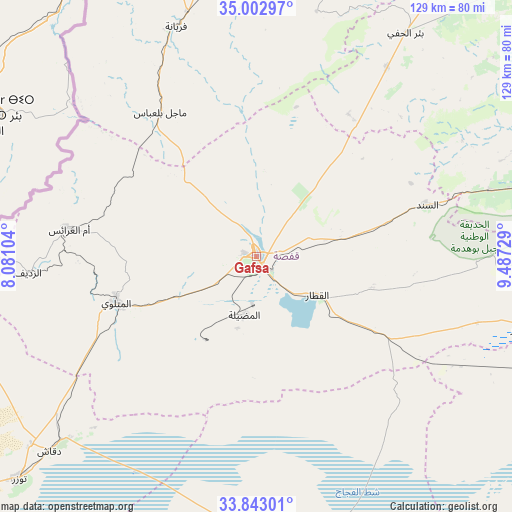
Gafsa GPS coordinates[2]
34° 25' 30" North, 8° 47' 3.012" East
| Map corner | latitude | longitude |
|---|---|---|
| Upper-left | 35.00297°, | 8.08104° |
| Center: | 34.425°, | 8.78417° |
| Lower-right: | 33.84301°, | 9.48729° |
| Map W x H: | 129×129 km | = 80.2×80.2mi |
| max Lat: | 37.27442° ⇑82.5% North |
| Gafsa: | 34.425° |
| min Lat: | ⇓17.5% South 32.31662° |
| min Long | Gafsa | max Long |
| 7.87765° | 8.78417° | 11.21965° |
| W 11.9%⇐ | ⇒88.1% E |
Elevation
Elevation of Gafsa is 295 m = 968 ft, and this is 145.6 m = 478 ft above average elevation for this country.
| Max E: |
999 m = 3278 ft | 17.5% |
| Gafsa | 295 m 968 ft | |
| Avg. | 149.4 m = 490 ft | |
Min E: |
-6 m = -20 ft | 82.5% |
See also: Gafsa elevation on elevation.city.
Geographical zone
Gafsa is located in North temperate zone (between Tropic of Cancer and the Arctic Circle). Distance of this Northern Tropic circle is 1221.8 km =759.2 mi to South.| Distance of | km | miles | from Gafsa |
|---|---|---|---|
| North Pole | 6179.4 | 3839.7 | to North |
| Arctic Circle | 3573.5 | 2220.5 | to North |
| Tropic Cancer | 1221.8 | 759.2 | to South |
| Equator | 3827.7 | 2378.4 | to South |


Nearby cities:
15 places around Gafsa: (largest is in red/bold)
• Ar Rudayyif
57.9 km =36 mi,  265°
265°
• As Sanad
44.2 km =27.5 mi,  84°
84°
• Bir el Hafey
67.7 km =42.1 mi,  33°
33°
• Chebika
78.8 km =49 mi,  261°
261°
• Degache
72.8 km =45.2 mi,  226°
226°
• Er Regueb
103.6 km =64.4 mi,  62°
62°
• Jemna
96.6 km =60 mi,  167°
167°
• Kasserine
82.7 km =51.4 mi,  3°
3°
• Kebili
81.9 km =50.9 mi, 168°
• Metlaoui
37 km =23 mi,  251°
251°
• Mezzouna
98.4 km =61.1 mi, 80°
• Nefta
103.6 km =64.4 mi, 233°
• Sidi Bouzid
93.5 km =58.1 mi,  43°
43°
• Tamaghzah
77.3 km =48 mi, 266°
• Tozeur
82.1 km =51 mi, 226°
Sources, notices
• [Note1] Compared only with cities in Tunisia existing in our database
• [Src1] Map data: © OpenStreetMap contributors (CC-BY-SA)
• [Src2] Other city data from geonames.org with taken over terms of usage.
• [Src3] Geographical zone / Annual Mean Temperature by Robert A. Rohde @ Wikipedia
