Kasserine geodata
Kasserine (Al Qaşrayn) is a seat of a first-order administrative division; located in Tunisia in Africa/Tunis (GMT+1) time zone. With population of 81,987 people, there are 7 cities with bigger population in this country. Compared to other cities in Tunisia, 74.8% of cities are located further ↑North; 87.4% of cities are located further →East and 96.5% of cities have lower elevation than Kasserine. Note1


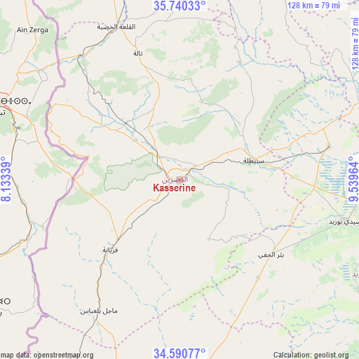
Kasserine GPS coordinates[2]
35° 10' 3.288" North, 8° 50' 11.436" East
| Map corner | latitude | longitude |
|---|---|---|
| Upper-left | 35.74033°, | 8.13339° |
| Center: | 35.16758°, | 8.83651° |
| Lower-right: | 34.59077°, | 9.53964° |
| Map W x H: | 127.8×127.8 km | = 79.4×79.4mi |
| max Lat: | 37.27442° ⇑74.8% North |
| Kasserine: | 35.16758° |
| min Lat: | ⇓25.2% South 32.31662° |
| min Long | Kasserine | max Long |
| 7.87765° | 8.83651° | 11.21965° |
| W 12.6%⇐ | ⇒87.4% E |
Elevation
Elevation of Kasserine is 674 m = 2211 ft, and this is 524.6 m = 1721 ft above average elevation for this country.
| Max E: |
999 m = 3278 ft | 3.5% |
| Kasserine | 674 m 2211 ft | |
| Avg. | 149.4 m = 490 ft | |
Min E: |
-6 m = -20 ft | 96.5% |
See also: Kasserine elevation on elevation.city.
Geographical zone
Kasserine is located in North temperate zone (between Tropic of Cancer and the Arctic Circle). Distance of this Northern Tropic circle is 1304.3 km =810.5 mi to South.| Distance of | km | miles | from Kasserine |
|---|---|---|---|
| North Pole | 6096.8 | 3788.4 | to North |
| Arctic Circle | 3490.9 | 2169.1 | to North |
| Tropic Cancer | 1304.3 | 810.5 | to South |
| Equator | 3910.3 | 2429.7 | to South |


Nearby cities:
15 places around Kasserine: (largest is in red/bold)
• As Sanad
87.5 km =54.4 mi,  153°
153°
• Bir el Hafey
41.7 km =25.9 mi,  128°
128°
• El Ksour
81.1 km =50.4 mi,  3°
3°
• Er Regueb
93.1 km =57.8 mi,  111°
111°
• Gafsa
82.7 km =51.4 mi,  183°
183°
• Haffouz
92 km =57.2 mi,  55°
55°
• Jilma
54.6 km =33.9 mi,  77°
77°
• Kesra
86.3 km =53.6 mi,  33°
33°
• Maktar
83.5 km =51.9 mi,  23°
23°
• Menzel Salem
83.3 km =51.8 mi,  336°
336°
• Rohia
57.3 km =35.6 mi, 20°
• Sbiba
47 km =29.2 mi, 27°
• Sidi Bouzid
60.7 km =37.7 mi,  103°
103°
• Tajerouine
84.5 km =52.5 mi, 342°
• Thala
47.5 km =29.5 mi, 341°
Sources, notices
• [Note1] Compared only with cities in Tunisia existing in our database
• [Src1] Map data: © OpenStreetMap contributors (CC-BY-SA)
• [Src2] Other city data from geonames.org with taken over terms of usage.
• [Src3] Geographical zone / Annual Mean Temperature by Robert A. Rohde @ Wikipedia
