Nefta geodata
Nefta (Tawzar) is a populated place; located in Tunisia in Africa/Tunis (GMT+1) time zone. With population of 21,720 people, there are 51 cities with bigger population in this country. Compared to other cities in Tunisia, 90.9% of cities are located further ↑North; 100% of cities are located further →East and 60.8% of cities have lower elevation than Nefta. Note1


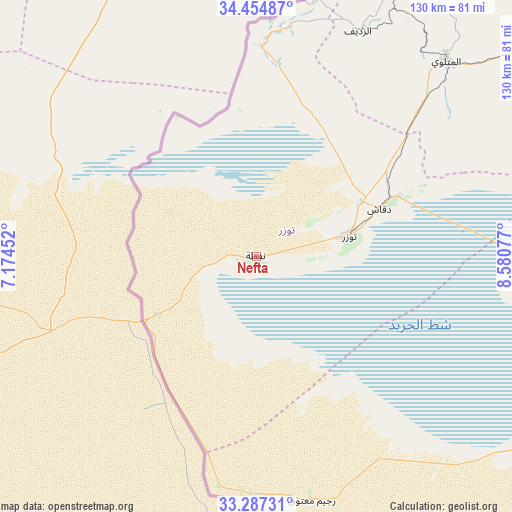
Nefta GPS coordinates[2]
33° 52' 23.124" North, 7° 52' 39.54" East
| Map corner | latitude | longitude |
|---|---|---|
| Upper-left | 34.45487°, | 7.17452° |
| Center: | 33.87309°, | 7.87765° |
| Lower-right: | 33.28731°, | 8.58077° |
| Map W x H: | 129.8×129.8 km | = 80.7×80.7mi |
| max Lat: | 37.27442° ⇑90.9% North |
| Nefta: | 33.87309° |
| min Lat: | ⇓9.1% South 32.31662° |
| min Long | Nefta | max Long |
| 7.87765° | 7.87765° | 11.21965° |
| W 0%⇐ | ⇒100% E |
Elevation
Elevation of Nefta is 65 m = 213 ft, and this is 84.4 m = 277 ft below average elevation for this country.
| Max E: |
999 m = 3278 ft | 39.2% |
| Avg. | 149.4 m = 490 ft | |
| Nefta | 65 m = 213 ft | |
Min E: |
-6 m = -20 ft | 60.8% |
See also: Tunisia elevation on elevation.city.
Geographical zone
Nefta is located in North temperate zone (between Tropic of Cancer and the Arctic Circle). Distance of this Northern Tropic circle is 1160.4 km =721 mi to South.| Distance of | km | miles | from Nefta |
|---|---|---|---|
| North Pole | 6240.7 | 3877.8 | to North |
| Arctic Circle | 3634.8 | 2258.6 | to North |
| Tropic Cancer | 1160.4 | 721 | to South |
| Equator | 3766.3 | 2340.3 | to South |


Nearby cities:
15 places around Nefta: (largest is in red/bold)
• Ar Rudayyif
62.2 km =38.6 mi,  24°
24°
• As Sanad
143.4 km =89.1 mi,  62°
62°
• Bir el Hafey
168.6 km =104.8 mi,  45°
45°
• Bou Attouche
176.1 km =109.4 mi,  89°
89°
• Chebika
49.9 km =31 mi,  6°
6°
• Degache
32.6 km =20.3 mi,  69°
69°
• Douz
115 km =71.5 mi,  113°
113°
• El Golaa
113 km =70.2 mi, 112°
• Gafsa
103.6 km =64.4 mi, 53°
• Jemna
110.2 km =68.5 mi, 107°
• Kasserine
168.6 km =104.8 mi,  31°
31°
• Kebili
102.6 km =63.8 mi,  100°
100°
• Metlaoui
69.3 km =43.1 mi,  44°
44°
• Tamaghzah
57.6 km =35.8 mi, 6°
• Tozeur
24.2 km =15 mi,  77°
77°
Sources, notices
• [Note1] Compared only with cities in Tunisia existing in our database
• [Src1] Map data: © OpenStreetMap contributors (CC-BY-SA)
• [Src2] Other city data from geonames.org with taken over terms of usage.
• [Src3] Geographical zone / Annual Mean Temperature by Robert A. Rohde @ Wikipedia
