Mezzouna geodata
Mezzouna (Sīdī Bū Zayd) is a populated place; located in Tunisia in Africa/Tunis (GMT+1) time zone. With population of 5,564 people, there are 115 cities with bigger population in this country. Compared to other cities in Tunisia, 81.1% of cities are located further ↑North; 65% of cities are located further →East and 72.7% of cities have lower elevation than Mezzouna. Note1


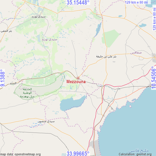
Mezzouna GPS coordinates[2]
34° 34' 39.288" North, 9° 50' 30.948" East
| Map corner | latitude | longitude |
|---|---|---|
| Upper-left | 35.15448°, | 9.1388° |
| Center: | 34.57758°, | 9.84193° |
| Lower-right: | 33.99665°, | 10.54506° |
| Map W x H: | 128.7×128.7 km | = 80×80mi |
| max Lat: | 37.27442° ⇑81.1% North |
| Mezzouna: | 34.57758° |
| min Lat: | ⇓18.9% South 32.31662° |
| min Long | Mezzouna | max Long |
| 7.87765° | 9.84193° | 11.21965° |
| W 35%⇐ | ⇒65% E |
Elevation
Elevation of Mezzouna is 155 m = 509 ft, and this is 5.6 m = 18 ft above average elevation for this country.
| Max E: |
999 m = 3278 ft | 27.3% |
| Mezzouna | 155 m 509 ft | |
| Avg. | 149.4 m = 490 ft | |
Min E: |
-6 m = -20 ft | 72.7% |
See also: Tunisia elevation on elevation.city.
Geographical zone
Mezzouna is located in North temperate zone (between Tropic of Cancer and the Arctic Circle). Distance of this Northern Tropic circle is 1238.7 km =769.7 mi to South.| Distance of | km | miles | from Mezzouna |
|---|---|---|---|
| North Pole | 6162.4 | 3829.1 | to North |
| Arctic Circle | 3556.5 | 2209.9 | to North |
| Tropic Cancer | 1238.7 | 769.7 | to South |
| Equator | 3844.7 | 2389 | to South |


Nearby cities:
15 places around Mezzouna: (largest is in red/bold)
• As Sanad
54.5 km =33.9 mi,  256°
256°
• Bir Ali Ben Khalifa
28.9 km =18 mi,  52°
52°
• Bir el Hafey
71.2 km =44.2 mi,  303°
303°
• Bou Attouche
75.6 km =47 mi,  183°
183°
• Chorbane
93.1 km =57.8 mi,  32°
32°
• Djebeniana
109.8 km =68.2 mi,  62°
62°
• El Hamma
76.4 km =47.5 mi, 183°
• Er Regueb
31.7 km =19.7 mi,  350°
350°
• Gabès
80.9 km =50.3 mi,  163°
163°
• Gafsa
98.4 km =61.1 mi, 260°
• Gremda
88.2 km =54.8 mi,  77°
77°
• Jilma
86.2 km =53.6 mi,  333°
333°
• Sfax
85.9 km =53.4 mi, 77°
• Sidi Bouzid
60.7 km =37.7 mi, 327°
• Skhira
37.4 km =23.2 mi,  145°
145°
Sources, notices
• [Note1] Compared only with cities in Tunisia existing in our database
• [Src1] Map data: © OpenStreetMap contributors (CC-BY-SA)
• [Src2] Other city data from geonames.org with taken over terms of usage.
• [Src3] Geographical zone / Annual Mean Temperature by Robert A. Rohde @ Wikipedia
