El Golaa geodata
El Golaa (Qibilī) is a populated place; located in Tunisia in Africa/Tunis (GMT+1) time zone. With population of 7,189 people, there are 99 cities with bigger population in this country. Compared to other cities in Tunisia, 95.8% of cities are located further ↑North; 85.3% of cities are located further →East and 55.2% of cities have lower elevation than El Golaa. Note1


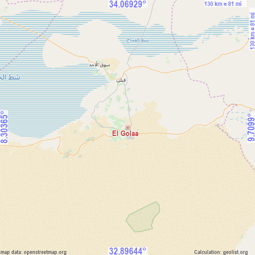
El Golaa GPS coordinates[2]
33° 29' 5.46" North, 9° 0' 24.408" East
| Map corner | latitude | longitude |
|---|---|---|
| Upper-left | 34.06929°, | 8.30365° |
| Center: | 33.48485°, | 9.00678° |
| Lower-right: | 32.89644°, | 9.7099° |
| Map W x H: | 130.4×130.4 km | = 81×81mi |
| max Lat: | 37.27442° ⇑95.8% North |
| El Golaa: | 33.48485° |
| min Lat: | ⇓4.2% South 32.31662° |
| min Long | El Golaa | max Long |
| 7.87765° | 9.00678° | 11.21965° |
| W 14.7%⇐ | ⇒85.3% E |
Elevation
Elevation of El Golaa is 56 m = 184 ft, and this is 93.4 m = 306 ft below average elevation for this country.
| Max E: |
999 m = 3278 ft | 44.8% |
| Avg. | 149.4 m = 490 ft | |
| El Golaa | 56 m = 184 ft | |
Min E: |
-6 m = -20 ft | 55.2% |
See also: Tunisia elevation on elevation.city.
Geographical zone
El Golaa is located in North temperate zone (between Tropic of Cancer and the Arctic Circle). Distance of this Northern Tropic circle is 1117.2 km =694.2 mi to South.| Distance of | km | miles | from El Golaa |
|---|---|---|---|
| North Pole | 6283.9 | 3904.6 | to North |
| Arctic Circle | 3678 | 2285.4 | to North |
| Tropic Cancer | 1117.2 | 694.2 | to South |
| Equator | 3723.2 | 2313.5 | to South |


Nearby cities:
15 places around El Golaa: (largest is in red/bold)
• Ar Rudayyif
127 km =78.9 mi,  321°
321°
• As Sanad
111.3 km =69.2 mi,  12°
12°
• Beni Kheddache
113.7 km =70.6 mi,  103°
103°
• Bou Attouche
85.5 km =53.1 mi,  57°
57°
• Degache
91.9 km =57.1 mi,  306°
306°
• Douz
2.4 km =1.5 mi,  148°
148°
• El Hamma
85.9 km =53.4 mi, 58°
• Gabès
110.2 km =68.5 mi,  66°
66°
• Gafsa
106.5 km =66.2 mi,  348°
348°
• Jemna
10.4 km =6.5 mi,  4°
4°
• Kebili
24.7 km =15.3 mi, 351°
• Matmata
89.7 km =55.7 mi,  85°
85°
• Metlaoui
108.4 km =67.4 mi,  328°
328°
• Nefta
113 km =70.2 mi,  292°
292°
• Tozeur
94.1 km =58.5 mi,  300°
300°
Sources, notices
• [Note1] Compared only with cities in Tunisia existing in our database
• [Src1] Map data: © OpenStreetMap contributors (CC-BY-SA)
• [Src2] Other city data from geonames.org with taken over terms of usage.
• [Src3] Geographical zone / Annual Mean Temperature by Robert A. Rohde @ Wikipedia
