Haffouz geodata
Haffouz (Kairouan) is a populated place; located in Tunisia in Africa/Tunis (GMT+1) time zone. With population of 7,765 people, there are 95 cities with bigger population in this country. Compared to other cities in Tunisia, 62.9% of cities are located further ↑North; 69.2% of cities are located further →East and 81.1% of cities have lower elevation than Haffouz. Note1


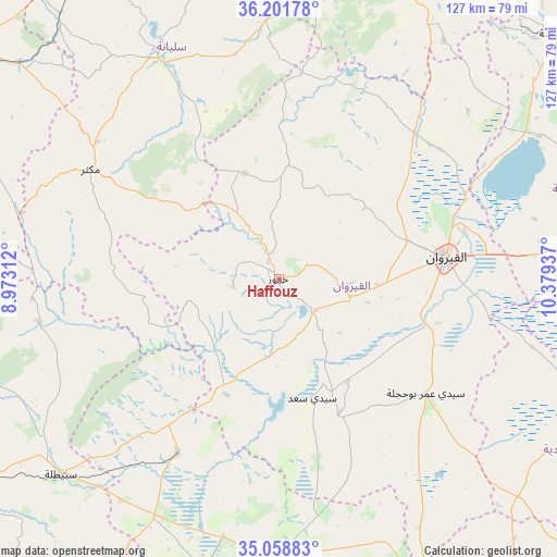
Haffouz GPS coordinates[2]
35° 37' 56.46" North, 9° 40' 34.464" East
| Map corner | latitude | longitude |
|---|---|---|
| Upper-left | 36.20178°, | 8.97312° |
| Center: | 35.63235°, | 9.67624° |
| Lower-right: | 35.05883°, | 10.37937° |
| Map W x H: | 127.1×127.1 km | = 79×79mi |
| max Lat: | 37.27442° ⇑62.9% North |
| Haffouz: | 35.63235° |
| min Lat: | ⇓37.1% South 32.31662° |
| min Long | Haffouz | max Long |
| 7.87765° | 9.67624° | 11.21965° |
| W 30.8%⇐ | ⇒69.2% E |
Elevation
Elevation of Haffouz is 284 m = 932 ft, and this is 134.6 m = 442 ft above average elevation for this country.
| Max E: |
999 m = 3278 ft | 18.9% |
| Haffouz | 284 m 932 ft | |
| Avg. | 149.4 m = 490 ft | |
Min E: |
-6 m = -20 ft | 81.1% |
See also: Tunisia elevation on elevation.city.
Geographical zone
Haffouz is located in North temperate zone (between Tropic of Cancer and the Arctic Circle). Distance of this Northern Tropic circle is 1356 km =842.6 mi to South.| Distance of | km | miles | from Haffouz |
|---|---|---|---|
| North Pole | 6045.1 | 3756.2 | to North |
| Arctic Circle | 3439.2 | 2137 | to North |
| Tropic Cancer | 1356 | 842.6 | to South |
| Equator | 3961.9 | 2461.8 | to South |


Nearby cities:
15 places around Haffouz: (largest is in red/bold)
• As Sars
77 km =47.8 mi,  309°
309°
• Bou Arada
80.2 km =49.8 mi,  356°
356°
• Chorbane
74.9 km =46.5 mi,  120°
120°
• El Ksour
77.2 km =48 mi,  292°
292°
• Jilma
46 km =28.6 mi,  209°
209°
• Kairouan
38.3 km =23.8 mi,  82°
82°
• Kesra
34.6 km =21.5 mi, 305°
• Maktar
49.7 km =30.9 mi,  300°
300°
• Rohia
56.4 km =35 mi,  272°
272°
• Sbiba
55.4 km =34.4 mi,  259°
259°
• Sbikha
45.7 km =28.4 mi,  42°
42°
• Sidi Bou Ali
80.4 km =50 mi,  63°
63°
• Sidi Bouzid
68.3 km =42.4 mi,  194°
194°
• Sidi el Hani
57.9 km =36 mi,  85°
85°
• Siliana
57.4 km =35.7 mi,  331°
331°
Sources, notices
• [Note1] Compared only with cities in Tunisia existing in our database
• [Src1] Map data: © OpenStreetMap contributors (CC-BY-SA)
• [Src2] Other city data from geonames.org with taken over terms of usage.
• [Src3] Geographical zone / Annual Mean Temperature by Robert A. Rohde @ Wikipedia
