Şile geodata
Şile (Istanbul) is a seat of a second-order administrative division; located in Turkey in Europe/Istanbul (GMT+3) time zone. With population of 11,596 people, there are 463 cities with bigger population in this country. Compared to other cities in Turkey, 93.6% of cities are located further ↓South; 78.6% of cities are located further →East and 89.2% of cities have higher elevation than Şile. Note1


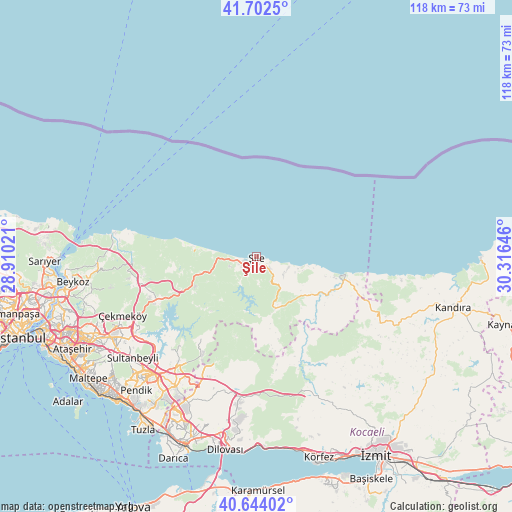
Şile GPS coordinates[2]
41° 10' 31.44" North, 29° 36' 47.988" East
| Map corner | latitude | longitude |
|---|---|---|
| Upper-left | 41.7025°, | 28.91021° |
| Center: | 41.1754°, | 29.61333° |
| Lower-right: | 40.64402°, | 30.31646° |
| Map W x H: | 117.7×117.7 km | = 73.1×73.1mi |
| max Lat: | 42.02683° ⇑6.4% North |
| Şile: | 41.1754° |
| min Lat: | ⇓93.6% South 35.9025° |
| min Long | Şile | max Long |
| 25.90902° | 29.61333° | 44.60099° |
| W 21.4%⇐ | ⇒78.6% E |
Elevation
Elevation of Şile is 43 m = 141 ft, and this is 674.4 m = 2213 ft below average elevation for this country.
| Max E: |
2682 m = 8799 ft | 89.2% |
| Avg. | 717.4 m = 2354 ft | |
| Şile | 43 m = 141 ft | |
Min E: |
0 m = 0 ft | 10.8% |
See also: Turkey elevation on elevation.city.
Geographical zone
Şile is located in North temperate zone (between Tropic of Cancer and the Arctic Circle). Distance of this Northern Tropic circle is 1972.4 km =1225.6 mi to South.| Distance of | km | miles | from Şile |
|---|---|---|---|
| North Pole | 5428.8 | 3373.3 | to North |
| Arctic Circle | 2822.9 | 1754.1 | to North |
| Tropic Cancer | 1972.4 | 1225.6 | to South |
| Equator | 4578.3 | 2844.8 | to South |


Nearby cities:
15 places around Şile: (largest is in red/bold)
• Akçaova
28.7 km =17.8 mi,  122°
122°
• Ağva
20.8 km =12.9 mi,  101°
101°
• Balçık
37.1 km =23.1 mi,  204°
204°
• Karacaköy
13.3 km =8.3 mi, 101°
• Mahmut Şevket Paşa
35.6 km =22.1 mi,  265°
265°
• Mollafeneri
33.7 km =20.9 mi, 197°
• Samandıra
38 km =23.6 mi,  238°
238°
• Sancaktepe
37.3 km =23.2 mi, 238°
• Sultanbeyli
37.3 km =23.2 mi,  230°
230°
• Tavşanlı
40.6 km =25.2 mi,  192°
192°
• Teke
13.2 km =8.2 mi,  165°
165°
• Yeşilvadi
12.8 km =8 mi, 242°
• Çat
29.4 km =18.3 mi,  146°
146°
• Çayırova
41.9 km =26 mi,  205°
205°
• Çekmeköy
39.4 km =24.5 mi,  247°
247°
Sources, notices
• [Note1] Compared only with cities in Turkey existing in our database
• [Src1] Map data: © OpenStreetMap contributors (CC-BY-SA)
• [Src2] Other city data from geonames.org with taken over terms of usage.
• [Src3] Geographical zone / Annual Mean Temperature by Robert A. Rohde @ Wikipedia
