Zeytinliova geodata
Zeytinliova (Manisa) is a seat of a third-order administrative division; located in Turkey in Europe/Istanbul (GMT+3) time zone. With population of 4,905 people, there are 730 cities with bigger population in this country. Compared to other cities in Turkey, 54.3% of cities are located further ↓South; 92.4% of cities are located further →East and 72% of cities have higher elevation than Zeytinliova. Note1


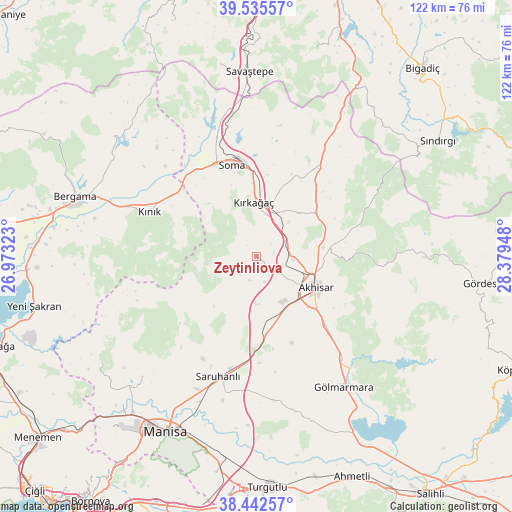
Zeytinliova GPS coordinates[2]
38° 59' 28.248" North, 27° 40' 34.86" East
| Map corner | latitude | longitude |
|---|---|---|
| Upper-left | 39.53557°, | 26.97323° |
| Center: | 38.99118°, | 27.67635° |
| Lower-right: | 38.44257°, | 28.37948° |
| Map W x H: | 121.5×121.5 km | = 75.5×75.5mi |
| max Lat: | 42.02683° ⇑45.7% North |
| Zeytinliova: | 38.99118° |
| min Lat: | ⇓54.3% South 35.9025° |
| min Long | Zeytinliova | max Long |
| 25.90902° | 27.67635° | 44.60099° |
| W 7.6%⇐ | ⇒92.4% E |
Elevation
Elevation of Zeytinliova is 236 m = 774 ft, and this is 481.4 m = 1579 ft below average elevation for this country.
| Max E: |
2682 m = 8799 ft | 72% |
| Avg. | 717.4 m = 2354 ft | |
| Zeytinliova | 236 m = 774 ft | |
Min E: |
0 m = 0 ft | 28% |
See also: Turkey elevation on elevation.city.
Geographical zone
Zeytinliova is located in North temperate zone (between Tropic of Cancer and the Arctic Circle). Distance of this Northern Tropic circle is 1729.5 km =1074.7 mi to South.| Distance of | km | miles | from Zeytinliova |
|---|---|---|---|
| North Pole | 5671.6 | 3524.2 | to North |
| Arctic Circle | 3065.8 | 1905 | to North |
| Tropic Cancer | 1729.5 | 1074.7 | to South |
| Equator | 4335.4 | 2693.9 | to South |


Nearby cities:
15 places around Zeytinliova: (largest is in red/bold)
• Akhisar
16.3 km =10.1 mi,  119°
119°
• Gelembe
25.6 km =15.9 mi,  35°
35°
• Gölcük
44.5 km =27.7 mi, 36°
• Gölmarmara
37.1 km =23.1 mi,  146°
146°
• Göçbeyli
34.9 km =21.7 mi,  317°
317°
• Halitpaşa
34 km =21.1 mi,  179°
179°
• Kınık
27.5 km =17.1 mi,  292°
292°
• Kırkağaç
12.8 km =8 mi,  357°
357°
• Osmancalı
44.6 km =27.7 mi,  235°
235°
• Saruhanlı
30 km =18.6 mi,  198°
198°
• Savaştepe
43.6 km =27.1 mi, 357°
• Soma
22.4 km =13.9 mi,  345°
345°
• Turanlı
43.9 km =27.3 mi, 316°
• Yuntdağ
40.6 km =25.2 mi,  260°
260°
• Üçpınar
39.5 km =24.5 mi,  223°
223°
Sources, notices
• [Note1] Compared only with cities in Turkey existing in our database
• [Src1] Map data: © OpenStreetMap contributors (CC-BY-SA)
• [Src2] Other city data from geonames.org with taken over terms of usage.
• [Src3] Geographical zone / Annual Mean Temperature by Robert A. Rohde @ Wikipedia
