Salmanlı geodata
Salmanlı (Yozgat) is a seat of a third-order administrative division; located in Turkey in Europe/Istanbul (GMT+3) time zone. In our database, there are 1323 cities with bigger population. Compared to other cities in Turkey, 67.3% of cities are located further ↓South; 57.6% of cities are located further →East and 69.5% of cities have lower elevation than Salmanlı. Note1


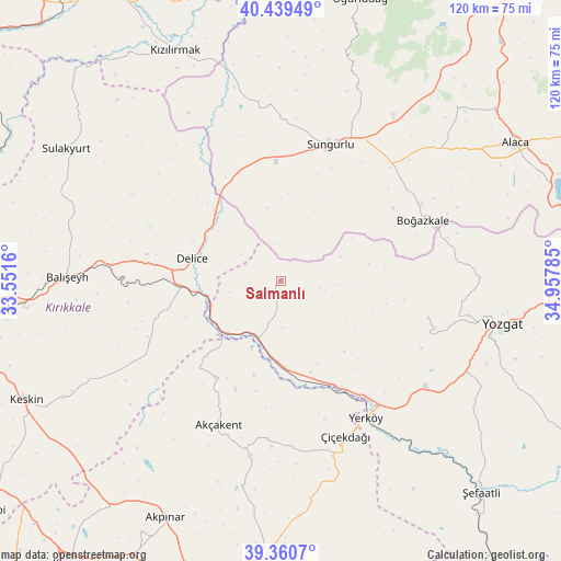
Salmanlı GPS coordinates[2]
39° 54' 7.992" North, 34° 15' 16.992" East
| Map corner | latitude | longitude |
|---|---|---|
| Upper-left | 40.43949°, | 33.5516° |
| Center: | 39.90222°, | 34.25472° |
| Lower-right: | 39.3607°, | 34.95785° |
| Map W x H: | 120×119.9 km | = 74.6×74.5mi |
| max Lat: | 42.02683° ⇑32.7% North |
| Salmanlı: | 39.90222° |
| min Lat: | ⇓67.3% South 35.9025° |
| min Long | Salmanlı | max Long |
| 25.90902° | 34.25472° | 44.60099° |
| W 42.4%⇐ | ⇒57.6% E |
Elevation
Elevation of Salmanlı is 1020 m = 3346 ft, and this is 302.6 m = 993 ft above average elevation for this country.
| Max E: |
2682 m = 8799 ft | 30.5% |
| Salmanlı | 1020 m 3346 ft | |
| Avg. | 717.4 m = 2354 ft | |
Min E: |
0 m = 0 ft | 69.5% |
See also: Turkey elevation on elevation.city.
Geographical zone
Salmanlı is located in North temperate zone (between Tropic of Cancer and the Arctic Circle). Distance of this Northern Tropic circle is 1830.8 km =1137.6 mi to South.| Distance of | km | miles | from Salmanlı |
|---|---|---|---|
| North Pole | 5570.4 | 3461.3 | to North |
| Arctic Circle | 2964.5 | 1842.1 | to North |
| Tropic Cancer | 1830.8 | 1137.6 | to South |
| Equator | 4436.7 | 2756.8 | to South |


Nearby cities:
15 places around Salmanlı: (largest is in red/bold)
• Akpınar
56.1 km =34.9 mi,  206°
206°
• Akçakent
33.9 km =21.1 mi,  203°
203°
• Alaca
58.1 km =36.1 mi,  59°
59°
• Balışeyh
45.3 km =28.1 mi,  271°
271°
• Boğazkale
33 km =20.5 mi,  66°
66°
• Delice
20.3 km =12.6 mi,  286°
286°
• Göllü
50.4 km =31.3 mi,  175°
175°
• Kösefakılı
35.8 km =22.2 mi, 196°
• Kızılırmak
54.3 km =33.7 mi,  335°
335°
• Musabeyli
32.4 km =20.1 mi,  103°
103°
• Sulakyurt
53.9 km =33.5 mi,  301°
301°
• Sungurlu
31.2 km =19.4 mi,  18°
18°
• Yerköy
34.5 km =21.4 mi,  148°
148°
• Yozgat
47.8 km =29.7 mi, 101°
• Çiçekdağı
35.4 km =22 mi,  158°
158°
Sources, notices
• [Note1] Compared only with cities in Turkey existing in our database
• [Src1] Map data: © OpenStreetMap contributors (CC-BY-SA)
• [Src2] Other city data from geonames.org with taken over terms of usage.
• [Src3] Geographical zone / Annual Mean Temperature by Robert A. Rohde @ Wikipedia
