Sungurlu geodata
Sungurlu (Çorum) is a seat of a second-order administrative division; located in Turkey in Europe/Istanbul (GMT+3) time zone. With population of 37,526 people, there are 212 cities with bigger population in this country. Compared to other cities in Turkey, 71.9% of cities are located further ↓South; 57% of cities are located further →East and 54% of cities have lower elevation than Sungurlu. Note1


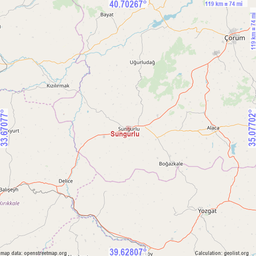
Sungurlu GPS coordinates[2]
40° 10' 3" North, 34° 22' 26.004" East
| Map corner | latitude | longitude |
|---|---|---|
| Upper-left | 40.70267°, | 33.67077° |
| Center: | 40.1675°, | 34.37389° |
| Lower-right: | 39.62807°, | 35.07702° |
| Map W x H: | 119.5×119.5 km | = 74.3×74.3mi |
| max Lat: | 42.02683° ⇑28.1% North |
| Sungurlu: | 40.1675° |
| min Lat: | ⇓71.9% South 35.9025° |
| min Long | Sungurlu | max Long |
| 25.90902° | 34.37389° | 44.60099° |
| W 43%⇐ | ⇒57% E |
Elevation
Elevation of Sungurlu is 774 m = 2539 ft, and this is 56.6 m = 186 ft above average elevation for this country.
| Max E: |
2682 m = 8799 ft | 46% |
| Sungurlu | 774 m 2539 ft | |
| Avg. | 717.4 m = 2354 ft | |
Min E: |
0 m = 0 ft | 54% |
See also: Turkey elevation on elevation.city.
Geographical zone
Sungurlu is located in North temperate zone (between Tropic of Cancer and the Arctic Circle). Distance of this Northern Tropic circle is 1860.3 km =1155.9 mi to South.| Distance of | km | miles | from Sungurlu |
|---|---|---|---|
| North Pole | 5540.9 | 3443 | to North |
| Arctic Circle | 2935 | 1823.7 | to North |
| Tropic Cancer | 1860.3 | 1155.9 | to South |
| Equator | 4466.2 | 2775.2 | to South |


Nearby cities:
15 places around Sungurlu: (largest is in red/bold)
• Alaca
39.8 km =24.7 mi,  89°
89°
• Balışeyh
62.1 km =38.6 mi,  243°
243°
• Bayat
54 km =33.6 mi,  349°
349°
• Boğazkale
25.8 km =16 mi,  128°
128°
• Cemilbey
60.8 km =37.8 mi,  71°
71°
• Delice
38 km =23.6 mi,  231°
231°
• Kızılırmak
38.4 km =23.9 mi,  301°
301°
• Musabeyli
42.8 km =26.6 mi,  150°
150°
• Salmanlı
31.2 km =19.4 mi,  198°
198°
• Seydim
51.9 km =32.2 mi,  36°
36°
• Sulakyurt
55.9 km =34.7 mi,  268°
268°
• Uğurludağ
31.7 km =19.7 mi,  12°
12°
• Yerköy
59.4 km =36.9 mi,  172°
172°
• Yozgat
53.3 km =33.1 mi,  136°
136°
• Çiçekdağı
62.4 km =38.8 mi,  177°
177°
Sources, notices
• [Note1] Compared only with cities in Turkey existing in our database
• [Src1] Map data: © OpenStreetMap contributors (CC-BY-SA)
• [Src2] Other city data from geonames.org with taken over terms of usage.
• [Src3] Geographical zone / Annual Mean Temperature by Robert A. Rohde @ Wikipedia
