Uzunkuyu geodata
Uzunkuyu (İzmir) is a seat of a third-order administrative division; located in Turkey in Europe/Istanbul (GMT+3) time zone. In our database, there are 1323 cities with bigger population. Compared to other cities in Turkey, 56.6% of cities are located further ↑North; 99% of cities are located further →East and 71.6% of cities have higher elevation than Uzunkuyu. Note1


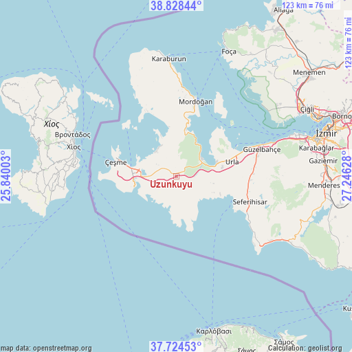
Uzunkuyu GPS coordinates[2]
38° 16' 42.888" North, 26° 32' 35.34" East
| Map corner | latitude | longitude |
|---|---|---|
| Upper-left | 38.82844°, | 25.84003° |
| Center: | 38.27858°, | 26.54315° |
| Lower-right: | 37.72453°, | 27.24628° |
| Map W x H: | 122.7×122.7 km | = 76.2×76.2mi |
| max Lat: | 42.02683° ⇑56.6% North |
| Uzunkuyu: | 38.27858° |
| min Lat: | ⇓43.4% South 35.9025° |
| min Long | Uzunkuyu | max Long |
| 25.90902° | 26.54315° | 44.60099° |
| W 1%⇐ | ⇒99% E |
Elevation
Elevation of Uzunkuyu is 244 m = 801 ft, and this is 473.4 m = 1553 ft below average elevation for this country.
| Max E: |
2682 m = 8799 ft | 71.6% |
| Avg. | 717.4 m = 2354 ft | |
| Uzunkuyu | 244 m = 801 ft | |
Min E: |
0 m = 0 ft | 28.4% |
See also: Turkey elevation on elevation.city.
Geographical zone
Uzunkuyu is located in North temperate zone (between Tropic of Cancer and the Arctic Circle). Distance of this Northern Tropic circle is 1650.3 km =1025.4 mi to South.| Distance of | km | miles | from Uzunkuyu |
|---|---|---|---|
| North Pole | 5750.9 | 3573.4 | to North |
| Arctic Circle | 3145 | 1954.2 | to North |
| Tropic Cancer | 1650.3 | 1025.4 | to South |
| Equator | 4256.2 | 2644.7 | to South |


Nearby cities:
15 places around Uzunkuyu: (largest is in red/bold)
• Alaçatı
14.7 km =9.1 mi,  271°
271°
• Buca
56 km =34.8 mi,  76°
76°
• Denizgiren
33.6 km =20.9 mi,  337°
337°
• Değirmendere
55.4 km =34.4 mi,  109°
109°
• Foça
47.4 km =29.5 mi,  23°
23°
• Gaziemir
51.4 km =31.9 mi, 84°
• Karabağlar
52.7 km =32.7 mi, 78°
• Karaburun
39.9 km =24.8 mi,  355°
355°
• Karşıyaka
53.3 km =33.1 mi,  68°
68°
• Menderes
51.7 km =32.1 mi,  93°
93°
• Mordoğan
27.4 km =17 mi, 15°
• Seferihisar
27.3 km =17 mi, 109°
• Urla
19.9 km =12.4 mi, 75°
• Çeşme
21.4 km =13.3 mi,  284°
284°
• İzmir
54 km =33.6 mi, 73°
Sources, notices
• [Note1] Compared only with cities in Turkey existing in our database
• [Src1] Map data: © OpenStreetMap contributors (CC-BY-SA)
• [Src2] Other city data from geonames.org with taken over terms of usage.
• [Src3] Geographical zone / Annual Mean Temperature by Robert A. Rohde @ Wikipedia
