Alaçatı geodata
Alaçatı (İzmir) is a seat of a third-order administrative division; located in Turkey in Europe/Istanbul (GMT+3) time zone. With population of 3,658 people, there are 810 cities with bigger population in this country. Compared to other cities in Turkey, 56.5% of cities are located further ↑North; 99.5% of cities are located further →East and 97.5% of cities have higher elevation than Alaçatı. Note1


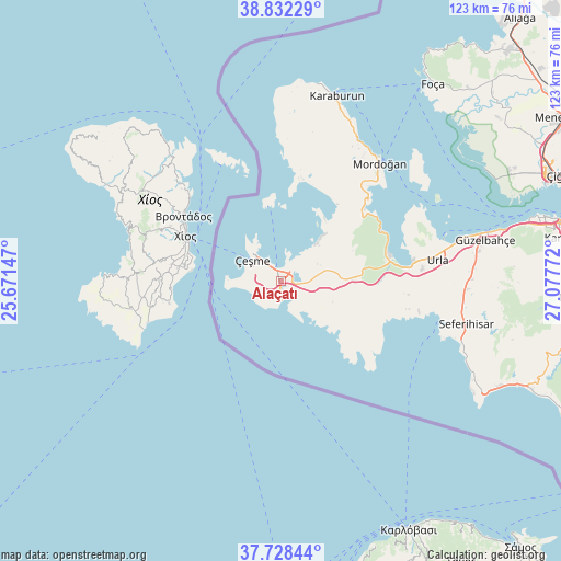
Alaçatı GPS coordinates[2]
38° 16' 56.856" North, 26° 22' 28.524" East
| Map corner | latitude | longitude |
|---|---|---|
| Upper-left | 38.83229°, | 25.67147° |
| Center: | 38.28246°, | 26.37459° |
| Lower-right: | 37.72844°, | 27.07772° |
| Map W x H: | 122.7×122.7 km | = 76.2×76.2mi |
| max Lat: | 42.02683° ⇑56.5% North |
| Alaçatı: | 38.28246° |
| min Lat: | ⇓43.5% South 35.9025° |
| min Long | Alaçatı | max Long |
| 25.90902° | 26.37459° | 44.60099° |
| W 0.5%⇐ | ⇒99.5% E |
Elevation
Elevation of Alaçatı is 11 m = 36 ft, and this is 706.4 m = 2318 ft below average elevation for this country.
| Max E: |
2682 m = 8799 ft | 97.5% |
| Avg. | 717.4 m = 2354 ft | |
| Alaçatı | 11 m = 36 ft | |
Min E: |
0 m = 0 ft | 2.5% |
See also: Turkey elevation on elevation.city.
Geographical zone
Alaçatı is located in North temperate zone (between Tropic of Cancer and the Arctic Circle). Distance of this Northern Tropic circle is 1650.7 km =1025.7 mi to South.| Distance of | km | miles | from Alaçatı |
|---|---|---|---|
| North Pole | 5750.5 | 3573.2 | to North |
| Arctic Circle | 3144.6 | 1954 | to North |
| Tropic Cancer | 1650.7 | 1025.7 | to South |
| Equator | 4256.6 | 2644.9 | to South |


Nearby cities:
15 places around Alaçatı: (largest is in red/bold)
• Denizgiren
30.6 km =19 mi,  3°
3°
• Değirmendere
69.6 km =43.2 mi,  105°
105°
• Foça
54.5 km =33.9 mi,  37°
37°
• Gaziemir
66 km =41 mi,  85°
85°
• Karabağlar
67.1 km =41.7 mi,  81°
81°
• Karaburun
41.1 km =25.5 mi,  16°
16°
• Karşıyaka
67 km =41.6 mi,  73°
73°
• Menderes
66.4 km =41.3 mi, 93°
• Mordoğan
33.9 km =21.1 mi, 39°
• Seferihisar
41.6 km =25.8 mi,  103°
103°
• Urla
34.3 km =21.3 mi, 82°
• Uzunkuyu
14.7 km =9.1 mi, 91°
• Yenifoça
64.1 km =39.8 mi, 38°
• Çeşme
7.7 km =4.8 mi,  308°
308°
• İzmir
68.2 km =42.4 mi, 77°
Sources, notices
• [Note1] Compared only with cities in Turkey existing in our database
• [Src1] Map data: © OpenStreetMap contributors (CC-BY-SA)
• [Src2] Other city data from geonames.org with taken over terms of usage.
• [Src3] Geographical zone / Annual Mean Temperature by Robert A. Rohde @ Wikipedia
