Akziyaret geodata
Akziyaret (Şanlıurfa) is a seat of a third-order administrative division; located in Turkey in Europe/Istanbul (GMT+3) time zone. In our database, there are 1323 cities with bigger population. Compared to other cities in Turkey, 79% of cities are located further ↑North; 65.9% of cities are located further ←West and 51.7% of cities have higher elevation than Akziyaret. Note1


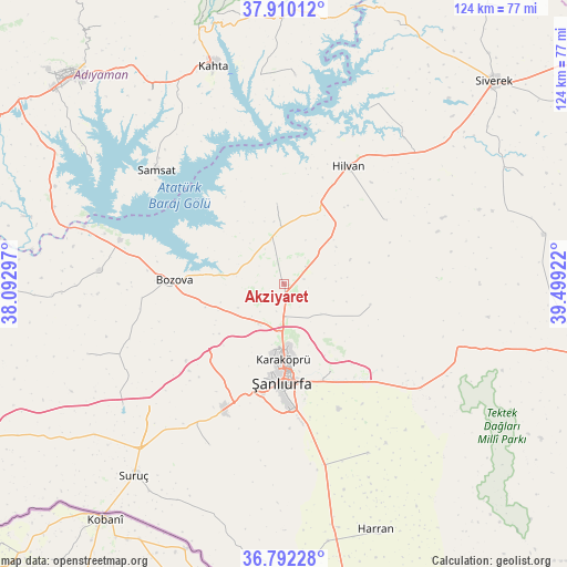
Akziyaret GPS coordinates[2]
37° 21' 11.808" North, 38° 47' 45.924" East
| Map corner | latitude | longitude |
|---|---|---|
| Upper-left | 37.91012°, | 38.09297° |
| Center: | 37.35328°, | 38.79609° |
| Lower-right: | 36.79228°, | 39.49922° |
| Map W x H: | 124.3×124.3 km | = 77.2×77.2mi |
| max Lat: | 42.02683° ⇑79% North |
| Akziyaret: | 37.35328° |
| min Lat: | ⇓21% South 35.9025° |
| min Long | Akziyaret | max Long |
| 25.90902° | 38.79609° | 44.60099° |
| W 65.9%⇐ | ⇒34.1% E |
Elevation
Elevation of Akziyaret is 662 m = 2172 ft, and this is 55.4 m = 182 ft below average elevation for this country.
| Max E: |
2682 m = 8799 ft | 51.7% |
| Avg. | 717.4 m = 2354 ft | |
| Akziyaret | 662 m = 2172 ft | |
Min E: |
0 m = 0 ft | 48.3% |
See also: Turkey elevation on elevation.city.
Geographical zone
Akziyaret is located in North temperate zone (between Tropic of Cancer and the Arctic Circle). Distance of this Northern Tropic circle is 1547.4 km =961.5 mi to South.| Distance of | km | miles | from Akziyaret |
|---|---|---|---|
| North Pole | 5853.8 | 3637.4 | to North |
| Arctic Circle | 3247.9 | 2018.2 | to North |
| Tropic Cancer | 1547.4 | 961.5 | to South |
| Equator | 4153.3 | 2580.7 | to South |


Nearby cities:
15 places around Akziyaret: (largest is in red/bold)
• Bozova
23.8 km =14.8 mi,  272°
272°
• Hilvan
29.5 km =18.3 mi,  28°
28°
• Kabahaydar
19.4 km =12.1 mi,  103°
103°
• Kabahaydar
25.9 km =16.1 mi,  78°
78°
• Karaköprü
16.6 km =10.3 mi,  178°
178°
• Ovacık
17.9 km =11.1 mi,  355°
355°
• Payamlı
38.8 km =24.1 mi,  204°
204°
• Samsat
38.1 km =23.7 mi,  311°
311°
• Tilfetis
26.4 km =16.4 mi,  57°
57°
• Yardımcı
41.3 km =25.7 mi,  153°
153°
• Yaylak
40.5 km =25.2 mi, 274°
• Yediyol
42 km =26.1 mi,  163°
163°
• Yukarı Çaykuyu
40 km =24.9 mi,  185°
185°
• Çamlıdere
32.6 km =20.3 mi,  132°
132°
• Şanlıurfa
20.7 km =12.9 mi, 180°
Sources, notices
• [Note1] Compared only with cities in Turkey existing in our database
• [Src1] Map data: © OpenStreetMap contributors (CC-BY-SA)
• [Src2] Other city data from geonames.org with taken over terms of usage.
• [Src3] Geographical zone / Annual Mean Temperature by Robert A. Rohde @ Wikipedia
