Bozova geodata
Bozova (Şanlıurfa) is a seat of a second-order administrative division; located in Turkey in Europe/Istanbul (GMT+3) time zone. With population of 21,502 people, there are 314 cities with bigger population in this country. Compared to other cities in Turkey, 78.7% of cities are located further ↑North; 64.4% of cities are located further ←West and 55.2% of cities have higher elevation than Bozova. Note1


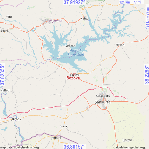
Bozova GPS coordinates[2]
37° 21' 45" North, 38° 31' 36.012" East
| Map corner | latitude | longitude |
|---|---|---|
| Upper-left | 37.91927°, | 37.82355° |
| Center: | 37.3625°, | 38.52667° |
| Lower-right: | 36.80157°, | 39.2298° |
| Map W x H: | 124.3×124.3 km | = 77.2×77.2mi |
| max Lat: | 42.02683° ⇑78.7% North |
| Bozova: | 37.3625° |
| min Lat: | ⇓21.3% South 35.9025° |
| min Long | Bozova | max Long |
| 25.90902° | 38.52667° | 44.60099° |
| W 64.4%⇐ | ⇒35.6% E |
Elevation
Elevation of Bozova is 583 m = 1913 ft, and this is 134.4 m = 441 ft below average elevation for this country.
| Max E: |
2682 m = 8799 ft | 55.2% |
| Avg. | 717.4 m = 2354 ft | |
| Bozova | 583 m = 1913 ft | |
Min E: |
0 m = 0 ft | 44.8% |
See also: Turkey elevation on elevation.city.
Geographical zone
Bozova is located in North temperate zone (between Tropic of Cancer and the Arctic Circle). Distance of this Northern Tropic circle is 1548.4 km =962.1 mi to South.| Distance of | km | miles | from Bozova |
|---|---|---|---|
| North Pole | 5852.7 | 3636.7 | to North |
| Arctic Circle | 3246.9 | 2017.5 | to North |
| Tropic Cancer | 1548.4 | 962.1 | to South |
| Equator | 4154.3 | 2581.4 | to South |


Nearby cities:
15 places around Bozova: (largest is in red/bold)
• Akpınar
35.8 km =22.2 mi,  311°
311°
• Akziyaret
23.8 km =14.8 mi,  92°
92°
• Bağpınar
31.4 km =19.5 mi,  324°
324°
• Böğürtlen
45.1 km =28 mi,  241°
241°
• Kabahaydar
43.1 km =26.8 mi,  97°
97°
• Kanlıavşar
25.2 km =15.7 mi,  229°
229°
• Karaköprü
29.9 km =18.6 mi,  126°
126°
• Kızılin
44.8 km =27.8 mi,  297°
297°
• Ovacık
27.9 km =17.3 mi,  53°
53°
• Payamlı
37.1 km =23.1 mi,  168°
168°
• Samsat
24.8 km =15.4 mi,  349°
349°
• Suruç
43.9 km =27.3 mi,  191°
191°
• Yaylak
16.7 km =10.4 mi,  277°
277°
• Yonlyu
44.5 km =27.7 mi,  196°
196°
• Şanlıurfa
32.1 km =19.9 mi, 132°
Sources, notices
• [Note1] Compared only with cities in Turkey existing in our database
• [Src1] Map data: © OpenStreetMap contributors (CC-BY-SA)
• [Src2] Other city data from geonames.org with taken over terms of usage.
• [Src3] Geographical zone / Annual Mean Temperature by Robert A. Rohde @ Wikipedia
