Başmakçı geodata
Başmakçı (Afyonkarahisar) is a seat of a second-order administrative division; located in Turkey in Europe/Istanbul (GMT+3) time zone. With population of 8,415 people, there are 559 cities with bigger population in this country. Compared to other cities in Turkey, 65.1% of cities are located further ↑North; 75.6% of cities are located further →East and 58.6% of cities have lower elevation than Başmakçı. Note1


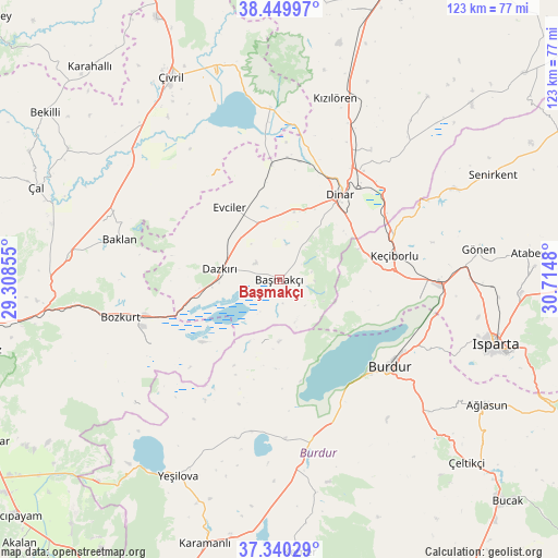
Başmakçı GPS coordinates[2]
37° 53' 49.992" North, 30° 0' 42.012" East
| Map corner | latitude | longitude |
|---|---|---|
| Upper-left | 38.44997°, | 29.30855° |
| Center: | 37.89722°, | 30.01167° |
| Lower-right: | 37.34029°, | 30.7148° |
| Map W x H: | 123.4×123.4 km | = 76.7×76.7mi |
| max Lat: | 42.02683° ⇑65.1% North |
| Başmakçı: | 37.89722° |
| min Lat: | ⇓34.9% South 35.9025° |
| min Long | Başmakçı | max Long |
| 25.90902° | 30.01167° | 44.60099° |
| W 24.4%⇐ | ⇒75.6% E |
Elevation
Elevation of Başmakçı is 858 m = 2815 ft, and this is 140.6 m = 461 ft above average elevation for this country.
| Max E: |
2682 m = 8799 ft | 41.4% |
| Başmakçı | 858 m 2815 ft | |
| Avg. | 717.4 m = 2354 ft | |
Min E: |
0 m = 0 ft | 58.6% |
See also: Turkey elevation on elevation.city.
Geographical zone
Başmakçı is located in North temperate zone (between Tropic of Cancer and the Arctic Circle). Distance of this Northern Tropic circle is 1607.9 km =999.1 mi to South.| Distance of | km | miles | from Başmakçı |
|---|---|---|---|
| North Pole | 5793.3 | 3599.8 | to North |
| Arctic Circle | 3187.4 | 1980.6 | to North |
| Tropic Cancer | 1607.9 | 999.1 | to South |
| Equator | 4213.8 | 2618.3 | to South |


Nearby cities:
15 places around Başmakçı: (largest is in red/bold)
• Baklan
36.4 km =22.6 mi,  284°
284°
• Bozkurt
36.2 km =22.5 mi,  257°
257°
• Burdur
31.4 km =19.5 mi,  128°
128°
• Dazkırı
13.5 km =8.4 mi, 280°
• Dinar
23 km =14.3 mi,  35°
35°
• Dombay
33.4 km =20.8 mi,  31°
31°
• Evciler
19.4 km =12.1 mi,  325°
325°
• Gönen
44.3 km =27.5 mi,  81°
81°
• Homa
38.1 km =23.7 mi,  356°
356°
• Keçiborlu
26 km =16.2 mi, 78°
• Kızılören
42 km =26.1 mi,  16°
16°
• Uluborlu
43.4 km =27 mi,  62°
62°
• Yeşilova
48.8 km =30.3 mi,  207°
207°
• Çardak
31.1 km =19.3 mi, 255°
• İshaklı
33.6 km =20.9 mi,  0°
0°
Sources, notices
• [Note1] Compared only with cities in Turkey existing in our database
• [Src1] Map data: © OpenStreetMap contributors (CC-BY-SA)
• [Src2] Other city data from geonames.org with taken over terms of usage.
• [Src3] Geographical zone / Annual Mean Temperature by Robert A. Rohde @ Wikipedia
