Tut geodata
Tut (Adıyaman) is a seat of a second-order administrative division; located in Turkey in Europe/Istanbul (GMT+3) time zone. With population of 7,560 people, there are 592 cities with bigger population in this country. Compared to other cities in Turkey, 68.6% of cities are located further ↑North; 61.3% of cities are located further ←West and 71.9% of cities have lower elevation than Tut. Note1


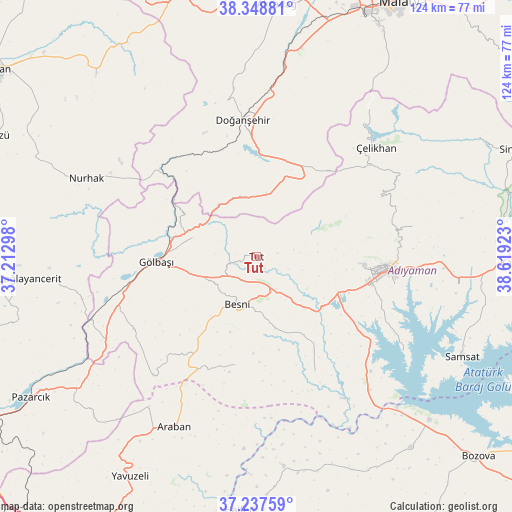
Tut GPS coordinates[2]
37° 47' 43.044" North, 37° 54' 57.96" East
| Map corner | latitude | longitude |
|---|---|---|
| Upper-left | 38.34881°, | 37.21298° |
| Center: | 37.79529°, | 37.9161° |
| Lower-right: | 37.23759°, | 38.61923° |
| Map W x H: | 123.6×123.6 km | = 76.8×76.8mi |
| max Lat: | 42.02683° ⇑68.6% North |
| Tut: | 37.79529° |
| min Lat: | ⇓31.4% South 35.9025° |
| min Long | Tut | max Long |
| 25.90902° | 37.9161° | 44.60099° |
| W 61.3%⇐ | ⇒38.7% E |
Elevation
Elevation of Tut is 1054 m = 3458 ft, and this is 336.6 m = 1104 ft above average elevation for this country.
| Max E: |
2682 m = 8799 ft | 28.1% |
| Tut | 1054 m 3458 ft | |
| Avg. | 717.4 m = 2354 ft | |
Min E: |
0 m = 0 ft | 71.9% |
See also: Turkey elevation on elevation.city.
Geographical zone
Tut is located in North temperate zone (between Tropic of Cancer and the Arctic Circle). Distance of this Northern Tropic circle is 1596.5 km =992 mi to South.| Distance of | km | miles | from Tut |
|---|---|---|---|
| North Pole | 5804.6 | 3606.8 | to North |
| Arctic Circle | 3198.7 | 1987.6 | to North |
| Tropic Cancer | 1596.5 | 992 | to South |
| Equator | 4202.4 | 2611.2 | to South |


Nearby cities:
15 places around Tut: (largest is in red/bold)
• Adıyaman
31.8 km =19.8 mi,  96°
96°
• Akpınar
36.4 km =22.6 mi,  132°
132°
• Belören
34.4 km =21.4 mi,  239°
239°
• Besni
12.4 km =7.7 mi,  202°
202°
• Doğanşehir
32.5 km =20.2 mi,  353°
353°
• Gölbaşı
24.6 km =15.3 mi,  266°
266°
• Harmanlı
15.8 km =9.8 mi,  287°
287°
• Keysun
26.6 km =16.5 mi,  191°
191°
• Koçali
33.2 km =20.6 mi,  64°
64°
• Kuyucak
38.3 km =23.8 mi,  78°
78°
• Kızılin
31 km =19.3 mi,  153°
153°
• Suvarlı
37.9 km =23.5 mi,  221°
221°
• Sürgü
23.7 km =14.7 mi,  10°
10°
• Çelikhan
38 km =23.6 mi,  47°
47°
• Şambayat
16.9 km =10.5 mi,  137°
137°
Sources, notices
• [Note1] Compared only with cities in Turkey existing in our database
• [Src1] Map data: © OpenStreetMap contributors (CC-BY-SA)
• [Src2] Other city data from geonames.org with taken over terms of usage.
• [Src3] Geographical zone / Annual Mean Temperature by Robert A. Rohde @ Wikipedia
