Gölbaşı geodata
Gölbaşı (Adıyaman) is a seat of a second-order administrative division; located in Turkey in Europe/Istanbul (GMT+3) time zone. With population of 28,078 people, there are 266 cities with bigger population in this country. Compared to other cities in Turkey, 68.8% of cities are located further ↑North; 59.6% of cities are located further ←West and 61.1% of cities have lower elevation than Gölbaşı. Note1


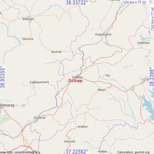
Gölbaşı GPS coordinates[2]
37° 47' 0.996" North, 37° 38' 12.012" East
| Map corner | latitude | longitude |
|---|---|---|
| Upper-left | 38.33722°, | 36.93355° |
| Center: | 37.78361°, | 37.63667° |
| Lower-right: | 37.22582°, | 38.3398° |
| Map W x H: | 123.6×123.6 km | = 76.8×76.8mi |
| max Lat: | 42.02683° ⇑68.8% North |
| Gölbaşı: | 37.78361° |
| min Lat: | ⇓31.2% South 35.9025° |
| min Long | Gölbaşı | max Long |
| 25.90902° | 37.63667° | 44.60099° |
| W 59.6%⇐ | ⇒40.4% E |
Elevation
Elevation of Gölbaşı is 898 m = 2946 ft, and this is 180.6 m = 593 ft above average elevation for this country.
| Max E: |
2682 m = 8799 ft | 38.9% |
| Gölbaşı | 898 m 2946 ft | |
| Avg. | 717.4 m = 2354 ft | |
Min E: |
0 m = 0 ft | 61.1% |
See also: Turkey elevation on elevation.city.
Geographical zone
Gölbaşı is located in North temperate zone (between Tropic of Cancer and the Arctic Circle). Distance of this Northern Tropic circle is 1595.2 km =991.2 mi to South.| Distance of | km | miles | from Gölbaşı |
|---|---|---|---|
| North Pole | 5805.9 | 3607.6 | to North |
| Arctic Circle | 3200 | 1988.4 | to North |
| Tropic Cancer | 1595.2 | 991.2 | to South |
| Equator | 4201.1 | 2610.4 | to South |


Nearby cities:
15 places around Gölbaşı: (largest is in red/bold)
• Araban
40 km =24.9 mi,  173°
173°
• Ağabeyli
46.1 km =28.6 mi,  263°
263°
• Belören
17 km =10.6 mi,  196°
196°
• Besni
22.2 km =13.8 mi,  117°
117°
• Doğanşehir
39.4 km =24.5 mi,  31°
31°
• Harmanlı
11.2 km =7 mi,  57°
57°
• Keysun
31.4 km =19.5 mi,  142°
142°
• Kızılin
46.8 km =29.1 mi, 124°
• Nurhak
26.4 km =16.4 mi,  319°
319°
• Pazarcık
44.4 km =27.6 mi,  221°
221°
• Suvarlı
27.2 km =16.9 mi,  180°
180°
• Sürgü
37.8 km =23.5 mi,  49°
49°
• Tut
24.6 km =15.3 mi,  86°
86°
• Çağlayancerit
31.1 km =19.3 mi, 262°
• Şambayat
37.7 km =23.4 mi,  107°
107°
Sources, notices
• [Note1] Compared only with cities in Turkey existing in our database
• [Src1] Map data: © OpenStreetMap contributors (CC-BY-SA)
• [Src2] Other city data from geonames.org with taken over terms of usage.
• [Src3] Geographical zone / Annual Mean Temperature by Robert A. Rohde @ Wikipedia
