Kuyucak geodata
Kuyucak (Adıyaman) is a seat of a third-order administrative division; located in Turkey in Europe/Istanbul (GMT+3) time zone. In our database, there are 1323 cities with bigger population. Compared to other cities in Turkey, 66.5% of cities are located further ↑North; 63.3% of cities are located further ←West and 67.5% of cities have lower elevation than Kuyucak. Note1


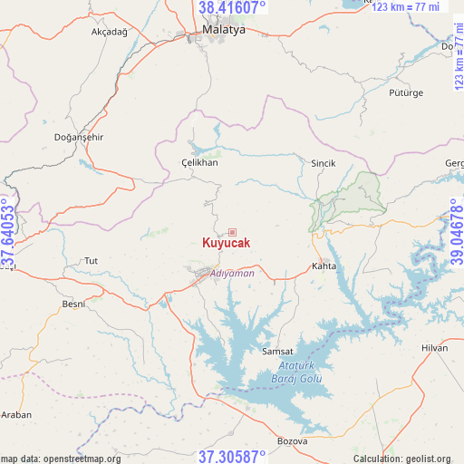
Kuyucak GPS coordinates[2]
37° 51' 47.016" North, 38° 20' 37.14" East
| Map corner | latitude | longitude |
|---|---|---|
| Upper-left | 38.41607°, | 37.64053° |
| Center: | 37.86306°, | 38.34365° |
| Lower-right: | 37.30587°, | 39.04678° |
| Map W x H: | 123.4×123.4 km | = 76.7×76.7mi |
| max Lat: | 42.02683° ⇑66.5% North |
| Kuyucak: | 37.86306° |
| min Lat: | ⇓33.5% South 35.9025° |
| min Long | Kuyucak | max Long |
| 25.90902° | 38.34365° | 44.60099° |
| W 63.3%⇐ | ⇒36.7% E |
Elevation
Elevation of Kuyucak is 993 m = 3258 ft, and this is 275.6 m = 904 ft above average elevation for this country.
| Max E: |
2682 m = 8799 ft | 32.5% |
| Kuyucak | 993 m 3258 ft | |
| Avg. | 717.4 m = 2354 ft | |
Min E: |
0 m = 0 ft | 67.5% |
See also: Turkey elevation on elevation.city.
Geographical zone
Kuyucak is located in North temperate zone (between Tropic of Cancer and the Arctic Circle). Distance of this Northern Tropic circle is 1604.1 km =996.7 mi to South.| Distance of | km | miles | from Kuyucak |
|---|---|---|---|
| North Pole | 5797.1 | 3602.1 | to North |
| Arctic Circle | 3191.2 | 1982.9 | to North |
| Tropic Cancer | 1604.1 | 996.7 | to South |
| Equator | 4210 | 2616 | to South |


Nearby cities:
15 places around Kuyucak: (largest is in red/bold)
• Adıyaman
12.5 km =7.8 mi,  208°
208°
• Akpınar
33.9 km =21.1 mi,  198°
198°
• Bağpınar
30.3 km =18.8 mi,  184°
184°
• Damlacık
27.8 km =17.3 mi,  78°
78°
• Koçali
10.1 km =6.3 mi,  311°
311°
• Kâhta
26.1 km =16.2 mi,  109°
109°
• Kızılin
42.3 km =26.3 mi, 213°
• Narince
36.5 km =22.7 mi,  86°
86°
• Samsat
33.3 km =20.7 mi,  159°
159°
• Sincik
30.5 km =19 mi,  50°
50°
• Sürgü
36.9 km =22.9 mi,  295°
295°
• Tut
38.3 km =23.8 mi,  258°
258°
• Yarpuzlu
26.3 km =16.3 mi,  36°
36°
• Çelikhan
20.4 km =12.7 mi,  332°
332°
• Şambayat
32.8 km =20.4 mi,  232°
232°
Sources, notices
• [Note1] Compared only with cities in Turkey existing in our database
• [Src1] Map data: © OpenStreetMap contributors (CC-BY-SA)
• [Src2] Other city data from geonames.org with taken over terms of usage.
• [Src3] Geographical zone / Annual Mean Temperature by Robert A. Rohde @ Wikipedia
